1900s (20th Century) Maps of Elgin, Oklahoma
Explore 6 historic maps of Elgin from the 1900s (20th Century). These maps offer a rare glimpse into what life looked like during the 1900s — showing old roads, neighborhoods, homes, and landmarks that have changed or disappeared over time.
Whether you're researching your family's past, planning a metal detecting trip, or studying how Elgin's landscape evolved across the 1900s, these high-resolution maps are a powerful tool for exploring the history of this region.
- Focus on a specific era: All maps on this page are from the 1900s, giving you a focused view of this time period.
- See what’s changed: Compare century-old streets, trails, and buildings to today's modern landscape using overlays and satellite layers.
- Research with precision: Use these maps for genealogy, historical research, land use analysis, or educational projects.
- View, download, or print: Maps are fully viewable online in high resolution, and can be downloaded or printed for your own records.
Start exploring Elgin's history through authentic maps from the 1900s. This is your window into the past.
Elgin, OK maps
(6)- 1949 Map of Elgin, 1953 Print
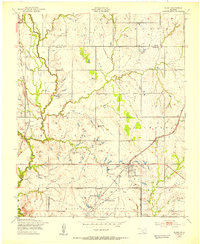 1949 Elgin1953 Print · USGSElgin and the surrounding Comanche County prairie are documented here just after the war as the region's rail and military presence defined local growth. Researchers can locate family landmarks such as St Anthonys Ch, Elgin Cem, and rural schools like Happy Hollow Sch.2 unique versions available
 - 1955 Map of Lawton, 1958 Print
 1955 Lawton1958 Print · USGSSouthwestern Oklahoma and North Texas are shown here in the mid-fifties, dominated by the Wichita Mountains and the vital Red River watershed. Genealogists and historians can trace the foundations of Lawton alongside rural landmarks like Rainy Mountain Church and Pleasant Hill School.5 unique versions available
 - 1956 Map of Elgin, 1959 Print
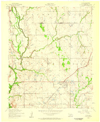 1956 Elgin1959 Print · USGSThe rail-and-ranching landscape of Oklahoma comes alive in the mid-fifties, centered on the junction of two major western railroads. Genealogists and historians can trace the local community through St Anthonys Church, the Elgin Cemetery, and the northern perimeter of the Fort Sill Military Reservation.3 unique versions available
 - 1956 Map of Apache, 1960 Print
 1956 Apache1960 Print · USGSCaddo and Comanche counties come into focus during the mid-fifties as agriculture and military operations define the local landscape. Researchers can trace rural landmarks from the Mahsetka Indian Church to the limestone works at Richards Spur and the rail sidings of Stecker.2 unique versions available
 - 1981 Map of Lawton
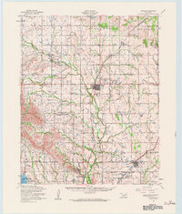
 1981 Lawton1981 Print · USGSSouthwestern Oklahoma in the early eighties shows a landscape shaped by military history and the rising peaks of the Wichitas. Researchers can trace the boundaries of the Fort Sill Military Reservation and locate early settlements like Meers, Chattanooga, and Richards Spur.
 - 1991 Map of Elgin, 1992 Print
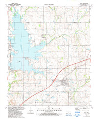 1991 Elgin1992 Print · USGSElgin and the Caddo-Comanche county line are captured here during the early nineties as lakeside developments expanded. Genealogists and local historians can trace family plots at St Ann Cem and Elgin Community Cem or locate old water features like Schammahorn Slough.
End of results
Showing maps 1-6 of 6
Top cities near Elgin
- Lawton historical maps
- Apache historical maps
- Cyril historical maps
- Fletcher historical maps
- Central High historical maps
- Empire City historical maps
See more
Frequently asked questions
- What are the different types of historical maps available for Elgin?
- What is the oldest map of Elgin?
- Where can I purchase historical maps of Elgin for my home or office?
- Where can I download high-res historical maps of Elgin?
- Are there historical topographic maps available for Elgin?
- Is there historical aerial imagery available for Elgin?
- Where are historical maps of Elgin sourced from?