1980s Maps of Dead Women Crossing, Oklahoma
Explore 2 historic maps of Dead Women Crossing from the 1980s. These maps offer a rare glimpse into what life looked like during the 1980s — showing old roads, neighborhoods, homes, and landmarks that have changed or disappeared over time.
Whether you're researching your family's past, planning a metal detecting trip, or studying how Dead Women Crossing's landscape evolved across the 1980s, these high-resolution maps are a powerful tool for exploring the history of this region.
- Focus on a specific era: All maps on this page are from the 1980s, giving you a focused view of this time period.
- See what’s changed: Compare century-old streets, trails, and buildings to today's modern landscape using overlays and satellite layers.
- Research with precision: Use these maps for genealogy, historical research, land use analysis, or educational projects.
- View, download, or print: Maps are fully viewable online in high resolution, and can be downloaded or printed for your own records.
Start exploring Dead Women Crossing's history through authentic maps from the 1980s. This is your window into the past.
Dead Women Crossing, OK maps
(2)- 1985 Map of Weatherford
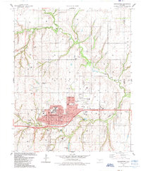 1985 Weatherford1985 Print · USGSWeatherford expanded as a center of education and industry in Western Oklahoma during the mid-eighties. Researchers can locate local landmarks like Southwestern State Univ, the Thomas P Stafford Airport, and historic burial grounds including Bradley Cem.
 - 1985 Map of Watonga
 1985 Watonga1985 Print · USGSCentral Oklahoma in the mid-eighties shows a robust network of river-valley settlements and rural rail lines. Genealogists and historians can trace the footprint of Southwestern State College, the historic Fort Reno, and family-named landmarks like Dead Women Crossing.2 unique versions available
End of results
Showing maps 1-2 of 2
Top cities near Dead Women Crossing
- Weatherford historical maps
- Clinton historical maps
- Thomas historical maps
- Corn historical maps
- Colony historical maps
Frequently asked questions
- What are the different types of historical maps available for Dead Women Crossing?
- What is the oldest map of Dead Women Crossing?
- Where can I purchase historical maps of Dead Women Crossing for my home or office?
- Where can I download high-res historical maps of Dead Women Crossing?
- Are there historical topographic maps available for Dead Women Crossing?
- Is there historical aerial imagery available for Dead Women Crossing?
- Where are historical maps of Dead Women Crossing sourced from?