1950s Maps of Rush Springs, Oklahoma
Explore 2 historic maps of Rush Springs from the 1950s. These maps offer a rare glimpse into what life looked like during the 1950s — showing old roads, neighborhoods, homes, and landmarks that have changed or disappeared over time.
Whether you're researching your family's past, planning a metal detecting trip, or studying how Rush Springs's landscape evolved across the 1950s, these high-resolution maps are a powerful tool for exploring the history of this region.
- Focus on a specific era: All maps on this page are from the 1950s, giving you a focused view of this time period.
- See what’s changed: Compare century-old streets, trails, and buildings to today's modern landscape using overlays and satellite layers.
- Research with precision: Use these maps for genealogy, historical research, land use analysis, or educational projects.
- View, download, or print: Maps are fully viewable online in high resolution, and can be downloaded or printed for your own records.
Start exploring Rush Springs's history through authentic maps from the 1950s. This is your window into the past.
Rush Springs, OK maps
(2)- 1950 Map of Rush Springs
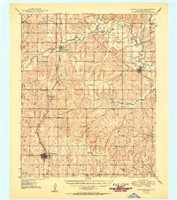 1950 Rush Springs1950 Print · USGSGrady County at the mid-point of the twentieth century reveals a landscape shaped by the Washita River and the local rail lines. Researchers can trace rural school locations like Vimy Ridge Sch and Hawkins Sch or locate family plots at Ireland Cem.2 unique versions available
 - 1957 Map of Ardmore, 1968 Print
 1957 Ardmore1968 Print · USGSSouth-central Oklahoma in the late fifties was a landscape of rising reservoir waters and expanding rail lines. Genealogists and historians can trace the foundations of Ardmore and Duncan or locate early recreation sites at Platt National Park and Lake Murray State Park.3 unique versions available
End of results
Showing maps 1-2 of 2
Top cities near Rush Springs
- Duncan historical maps
- Chickasha historical maps
- Marlow historical maps
- Ninnekah historical maps
- Bray historical maps
- Central High historical maps
See more
Frequently asked questions
- What are the different types of historical maps available for Rush Springs?
- What is the oldest map of Rush Springs?
- Where can I purchase historical maps of Rush Springs for my home or office?
- Where can I download high-res historical maps of Rush Springs?
- Are there historical topographic maps available for Rush Springs?
- Is there historical aerial imagery available for Rush Springs?
- Where are historical maps of Rush Springs sourced from?