1980s Maps of Rush Springs, Oklahoma
Explore 2 historic maps of Rush Springs from the 1980s. These maps offer a rare glimpse into what life looked like during the 1980s — showing old roads, neighborhoods, homes, and landmarks that have changed or disappeared over time.
Whether you're researching your family's past, planning a metal detecting trip, or studying how Rush Springs's landscape evolved across the 1980s, these high-resolution maps are a powerful tool for exploring the history of this region.
- Focus on a specific era: All maps on this page are from the 1980s, giving you a focused view of this time period.
- See what’s changed: Compare century-old streets, trails, and buildings to today's modern landscape using overlays and satellite layers.
- Research with precision: Use these maps for genealogy, historical research, land use analysis, or educational projects.
- View, download, or print: Maps are fully viewable online in high resolution, and can be downloaded or printed for your own records.
Start exploring Rush Springs's history through authentic maps from the 1980s. This is your window into the past.
Rush Springs, OK maps
(2)- 1981 Map of Rush Springs, 1982 Print
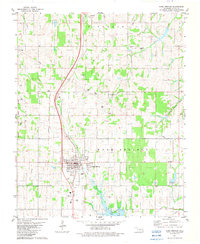 1981 Rush Springs1982 Print · USGSOklahoma's Grady County comes into focus in the early eighties, centered on the vital water sources and tribal lands of the southern plains. Trace historical land divisions along the Old Indian Territory Boundary or locate local landmarks like Carter Spr and the Cem near Rush Springs.
 - 1986 Map of Pauls Valley
 1986 Pauls Valley1986 Print · USGSGarvin County and its neighbors are shown in the mid-1980s during a period of steady growth along the Washita River. Researchers can trace the path of the Atchison Topeka and Santa Fe railroad through Pauls Valley or locate rural sites like Mt Olive Church and Erin Springs.2 unique versions available
End of results
Showing maps 1-2 of 2
Top cities near Rush Springs
- Duncan historical maps
- Chickasha historical maps
- Marlow historical maps
- Ninnekah historical maps
- Bray historical maps
- Central High historical maps
See more
Frequently asked questions
- What are the different types of historical maps available for Rush Springs?
- What is the oldest map of Rush Springs?
- Where can I purchase historical maps of Rush Springs for my home or office?
- Where can I download high-res historical maps of Rush Springs?
- Are there historical topographic maps available for Rush Springs?
- Is there historical aerial imagery available for Rush Springs?
- Where are historical maps of Rush Springs sourced from?