1960s Maps of Harmon County, Oklahoma
Explore 5 historic maps of Harmon County from the 1960s. These maps offer a rare glimpse into what life looked like during the 1960s — showing old roads, neighborhoods, homes, and landmarks that have changed or disappeared over time.
Whether you're researching your family's past, planning a metal detecting trip, or studying how Harmon County's landscape evolved across the 1960s, these high-resolution maps are a powerful tool for exploring the history of this region.
- Focus on a specific era: All maps on this page are from the 1960s, giving you a focused view of this time period.
- See what’s changed: Compare century-old streets, trails, and buildings to today's modern landscape using overlays and satellite layers.
- Research with precision: Use these maps for genealogy, historical research, land use analysis, or educational projects.
- View, download, or print: Maps are fully viewable online in high resolution, and can be downloaded or printed for your own records.
Start exploring Harmon County's history through authentic maps from the 1960s. This is your window into the past.
Harmon County, OK maps
(5)- 1960 Map of Loco, 1962 Print
 1960 Loco1962 Print · USGSChildress and Collingsworth counties are captured here in the early sixties, as the cattle and cotton country straddles the Oklahoma border. Researchers can trace rural lineages through the Loco Cem, find former school sites like Garden Valley Sch, or follow the Fort Worth and Denver rail line.
 - 1961 Map of Erick, 1963 Print
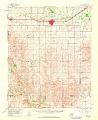 1961 Erick1963 Print · USGSBeckham County, Oklahoma, sits at the intersection of the Texas border and the great rail lines during the early 1960s. Family historians can trace the community life of Erick and Texola, finding specific landmarks like Munnerson Cem and the local Drive-in Theater.2 unique versions available
 - 1961 Map of Hollis, 1963 Print
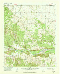
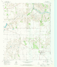
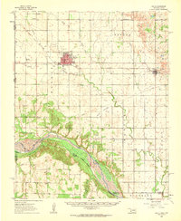 1961 Hollis1963 Print · USGSHarmon County, Oklahoma, in the early sixties showcases a landscape defined by the Prairie Dog Town Fork Red River and the arrival of modern infrastructure. Researchers can locate family landmarks like Bitter Creek Cem, Antioch Ch, and the local Drive-in Theater in Hollis.
 - 1963 Map of Little Wolf Creek, 1967 Print
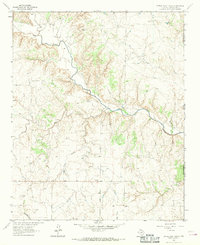 1963 Little Wolf Creek1967 Print · USGSThe Texas-Oklahoma borderlands in the early 1960s are defined by high plains drainage and isolated ranching outposts. Genealogists and historians can locate the Needwood Cem, trace the remote Jeep Trail, and find landmarks like Antelope Peak or the Lost Creek Ranch.
 - 1964 Map of Dodson, 1967 Print
 1964 Dodson1967 Print · USGSThe community of Dodson sits at the Texas and Oklahoma border in the mid-1960s, where the high plains meet the river breaks. Genealogists can trace family locations near Dodson Cem, Kelley Ch, and the remnants of the Old RR Grade.
End of results
Showing maps 1-5 of 5
Top cities of Harmon County
Frequently asked questions
- What are the different types of historical maps available for Harmon County?
- What is the oldest map of Harmon County?
- Where can I purchase historical maps of Harmon County for my home or office?
- Where can I download high-res historical maps of Harmon County?
- Are there historical topographic maps available for Harmon County?
- Is there historical aerial imagery available for Harmon County?
- Where are historical maps of Harmon County sourced from?