1960s Maps of Altus, Oklahoma
Explore 2 historic maps of Altus from the 1960s. These maps offer a rare glimpse into what life looked like during the 1960s — showing old roads, neighborhoods, homes, and landmarks that have changed or disappeared over time.
Whether you're researching your family's past, planning a metal detecting trip, or studying how Altus's landscape evolved across the 1960s, these high-resolution maps are a powerful tool for exploring the history of this region.
- Focus on a specific era: All maps on this page are from the 1960s, giving you a focused view of this time period.
- See what’s changed: Compare century-old streets, trails, and buildings to today's modern landscape using overlays and satellite layers.
- Research with precision: Use these maps for genealogy, historical research, land use analysis, or educational projects.
- View, download, or print: Maps are fully viewable online in high resolution, and can be downloaded or printed for your own records.
Start exploring Altus's history through authentic maps from the 1960s. This is your window into the past.
Altus, OK maps
(2)- 1963 Map of Altus SE, 1965 Print
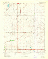 1963 Altus SE1965 Print · USGSJackson County agriculture meets burgeoning rail infrastructure in the early sixties south of Altus. Genealogists can locate Elmer Cem and Francis Cem near the Atchison Topeka and Santa Fe tracks.2 unique versions available
 - 1964 Map of Altus, 1965 Print
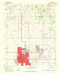 1964 Altus1965 Print · USGSJackson County in the mid-sixties serves as a vital military and railroad junction, anchored by the expansion of the regional seat. Genealogists and historians can locate legacy sites like Restlawn Memorial Park, the Jr College, and the sprawling Altus Air Force Base.2 unique versions available
End of results
Showing maps 1-2 of 2
Top cities near Altus
- Mangum historical maps
- Tipton historical maps
- Blair historical maps
- Olustee historical maps
- Martha historical maps
- Headrick historical maps
See more
Top neighborhoods of Altus
Frequently asked questions
- What are the different types of historical maps available for Altus?
- What is the oldest map of Altus?
- Where can I purchase historical maps of Altus for my home or office?
- Where can I download high-res historical maps of Altus?
- Are there historical topographic maps available for Altus?
- Is there historical aerial imagery available for Altus?
- Where are historical maps of Altus sourced from?