1990s Maps of Cooperton, Oklahoma
Explore 2 historic maps of Cooperton from the 1990s. These maps offer a rare glimpse into what life looked like during the 1990s — showing old roads, neighborhoods, homes, and landmarks that have changed or disappeared over time.
Whether you're researching your family's past, planning a metal detecting trip, or studying how Cooperton's landscape evolved across the 1990s, these high-resolution maps are a powerful tool for exploring the history of this region.
- Focus on a specific era: All maps on this page are from the 1990s, giving you a focused view of this time period.
- See what’s changed: Compare century-old streets, trails, and buildings to today's modern landscape using overlays and satellite layers.
- Research with precision: Use these maps for genealogy, historical research, land use analysis, or educational projects.
- View, download, or print: Maps are fully viewable online in high resolution, and can be downloaded or printed for your own records.
Start exploring Cooperton's history through authentic maps from the 1990s. This is your window into the past.
Cooperton, OK maps
(2)- 1991 Map of Glen Mountains, 1992 Print
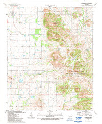
 1991 Glen Mountains1992 Print · USGSThe Oklahoma landscape in the early nineties is defined here by the waters of the Tom Steed Reservoir. Researchers can trace the development of Great Plains State Park and locate a Mine (Abandoned) or Quarry within the Glen Mountains.
 - 1991 Map of Cooperton, 1992 Print
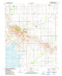
 1991 Cooperton1992 Print · USGSThe Kiowa and Comanche county line area comes into focus in the early 1990s, where agricultural plains meet the granite peaks of the southwest. Researchers can locate the Springhill Cem, trace the waters of Cut Throat Lake, and explore the high ground of Mount Pinchot.
End of results
Showing maps 1-2 of 2
Top cities near Cooperton
- Hobart historical maps
- Snyder historical maps
- Mountain Park historical maps
- Roosevelt historical maps
- Gotebo historical maps
Frequently asked questions
- What are the different types of historical maps available for Cooperton?
- What is the oldest map of Cooperton?
- Where can I purchase historical maps of Cooperton for my home or office?
- Where can I download high-res historical maps of Cooperton?
- Are there historical topographic maps available for Cooperton?
- Is there historical aerial imagery available for Cooperton?
- Where are historical maps of Cooperton sourced from?