1970s Maps of Chandler, Oklahoma
Explore 3 historic maps of Chandler from the 1970s. These maps offer a rare glimpse into what life looked like during the 1970s — showing old roads, neighborhoods, homes, and landmarks that have changed or disappeared over time.
Whether you're researching your family's past, planning a metal detecting trip, or studying how Chandler's landscape evolved across the 1970s, these high-resolution maps are a powerful tool for exploring the history of this region.
- Focus on a specific era: All maps on this page are from the 1970s, giving you a focused view of this time period.
- See what’s changed: Compare century-old streets, trails, and buildings to today's modern landscape using overlays and satellite layers.
- Research with precision: Use these maps for genealogy, historical research, land use analysis, or educational projects.
- View, download, or print: Maps are fully viewable online in high resolution, and can be downloaded or printed for your own records.
Start exploring Chandler's history through authentic maps from the 1970s. This is your window into the past.
Chandler, OK maps
(3)- 1974 Map of Chandler, 1977 Print
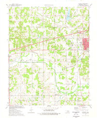 1974 Chandler1977 Print · USGSChandler and the surrounding Lincoln County countryside are captured here in the mid-1970s, showcasing a landscape shaped by petroleum and transportation. Genealogists and local historians can locate many rural landmarks including Sweet Home Cem, Mt Moriah Cem, and the settlement of Midlothian.
 - 1974 Map of Davenport, 1977 Print
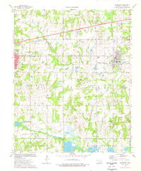 1974 Davenport1977 Print · USGSLincoln County centers on Chandler and Davenport during the mid-seventies, a landscape defined by intensive energy production and rail history. Genealogists and researchers can trace family sites at Cardwell Cem, Booker Cem, and New Zion Chapel.
 - 1975 Map of Tryon South, 1979 Print
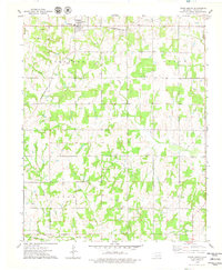 1975 Tryon South1979 Print · USGSLincoln County, Oklahoma, in the mid-seventies reveals a landscape defined by petroleum extraction and early rail corridors. Researchers can locate active Oil Wells and a central Oil Field alongside rural landmarks like Valley Queen Cem and the Rock Spring Cem.
End of results
Showing maps 1-3 of 3
Top cities near Chandler
- Oklahoma City historical maps
- Cushing historical maps
- Prague historical maps
- Meeker historical maps
- Davenport historical maps
- Wellston historical maps
See more
Frequently asked questions
- What are the different types of historical maps available for Chandler?
- What is the oldest map of Chandler?
- Where can I purchase historical maps of Chandler for my home or office?
- Where can I download high-res historical maps of Chandler?
- Are there historical topographic maps available for Chandler?
- Is there historical aerial imagery available for Chandler?
- Where are historical maps of Chandler sourced from?