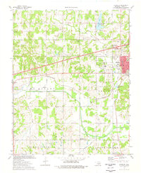
1974 Map of Chandler
USGS Topo · Published 1977About this map
The city of Chandler serves as a hub of civic and industrial activity in the mid-1970s, defined by the intersection of traditional rail lines and modern high-speed transit. The St Louis-San Francisco railroad and an Old Railroad Grade trace the historical movement of goods, while the Turner Turnpike cuts a modern path across the landscape. Surrounding the urban center, a dense Oil Field is evidenced by numerous Oil Wells and Gas Wells, reflecting the region's energy economy. This survey documents the social fabric of Lincoln County through its many rural institutions, including Sweet Home Ch and several family-named burial grounds such as McCorkle Cem and Star Valley Cem. Water features like Chandler Lake and Bellcow Creek are mapped alongside essential infrastructure like the Armory and Courthouse, providing a detailed look at the county seat during a period of steady development.
Find a feature on this map
53 named features on this map. Tap any name to fly to it.
Don’t see what you’re looking for? This feature index may not catch every label — zoom into the map to look around manually.
Map Details
Editions of this 1974 Chandler Map
This is the sole edition of this map. No revisions or reprints were ever made.
Other maps of this area

1905 · Chandler
USGS Topo · 1:62,500

1907 · Chandler
USGS Topo · 1:62,500

1908 · Agra
USGS Topo · 1:62,500

1909 · Luther
USGS Topo · 1:62,500

1909 · Perkins
USGS Topo · 1:62,500

1954 · Oklahoma City
USGS Topo · 1:250,000

1957 · Oklahoma City
USGS Topo · 1:250,000

1963 · Oklahoma City
USGS Topo · 1:250,000
1966 · Luther SE
USGS Topo · 1:24,000
1966 · Wellston
USGS Topo · 1:24,000