1900s (20th Century) Maps of Meridian, Oklahoma
Explore 7 historic maps of Meridian from the 1900s (20th Century). These maps offer a rare glimpse into what life looked like during the 1900s — showing old roads, neighborhoods, homes, and landmarks that have changed or disappeared over time.
Whether you're researching your family's past, planning a metal detecting trip, or studying how Meridian's landscape evolved across the 1900s, these high-resolution maps are a powerful tool for exploring the history of this region.
- Focus on a specific era: All maps on this page are from the 1900s, giving you a focused view of this time period.
- See what’s changed: Compare century-old streets, trails, and buildings to today's modern landscape using overlays and satellite layers.
- Research with precision: Use these maps for genealogy, historical research, land use analysis, or educational projects.
- View, download, or print: Maps are fully viewable online in high resolution, and can be downloaded or printed for your own records.
Start exploring Meridian's history through authentic maps from the 1900s. This is your window into the past.
Meridian, OK maps
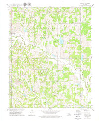
(7)- 1909 Map of Perkins
 1909 Perkins1909 Print · USGSOklahoma Territory near the turn of the century is a landscape of new rail-side towns and scattered one-room schoolhouses. Genealogists and historians can trace family roots through dozens of named sites like Vim PO, Mt Bethel Church, and Eagle College School.4 unique versions available
 - 1954 Map of Oklahoma City
 1954 Oklahoma City1954 Print · USGSOklahoma City and its surrounding counties are captured here in the early fifties during a period of significant postwar growth. Researchers can trace the development of the Turner Turnpike and locate aviation hubs like Tinker Field or Will Rogers Field.
 - 1957 Map of Oklahoma City, 1969 Print
 1957 Oklahoma City1969 Print · USGSCentral Oklahoma is captured here in a period of significant mid-century growth and industrialization. Researchers can trace family roots through numerous rural markers like Memory Lane Cem, New Hope School, and the sprawling grounds of Tinker Air Force Base.3 unique versions available
 - 1963 Map of Oklahoma City
 1963 Oklahoma City1963 Print · USGSCentral Oklahoma in the early sixties showcases a landscape of rapid suburban growth and established oil production. Researchers can trace historic rail lines like the Chicago Rock Island and Pacific RR or locate rural landmarks such as Mayflower School and Bethel Church.
 - 1970 Map of Guthrie SE, 1972 Print
 1970 Guthrie SE1972 Print · USGSLogan County oil production and rural life meet in this early 1970s study of the Oklahoma landscape. Researchers can trace family sites at Oak Ridge Cemetery or locate industrial landmarks like the Northwest Evansville Oil Field.
 - 1978 Map of Meridian, 1979 Print
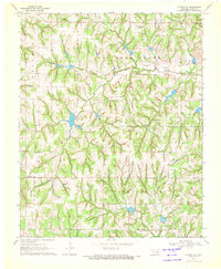
 1978 Meridian1979 Print · USGSOklahoma's rural borderlands between Logan and Lincoln Counties are captured here in the late seventies. Researchers can trace family history through numerous landmarks like Iowa Mission Cem, the Shiloh church, and the Old Railroad Grade.
 - 1990 Map of Oklahoma City North
 1990 Oklahoma City North1990 Print · USGSOklahoma City and its northern reaches are captured in the 1990s as suburban growth stretched toward the Cimarron River. Genealogists and historians can trace rail-town legacies along the Atchison Topeka and Santa Fe Railroad and find landmarks like the El Reno Federal Reformatory.
End of results
Showing maps 1-7 of 7
Top cities near Meridian
- Oklahoma City historical maps
- Edmond historical maps
- Guthrie historical maps
- Perkins historical maps
- Langston historical maps
- Luther historical maps
See more
Frequently asked questions
- What are the different types of historical maps available for Meridian?
- What is the oldest map of Meridian?
- Where can I purchase historical maps of Meridian for my home or office?
- Where can I download high-res historical maps of Meridian?
- Are there historical topographic maps available for Meridian?
- Is there historical aerial imagery available for Meridian?
- Where are historical maps of Meridian sourced from?