1960s Maps of Patton, Oklahoma
Explore 2 historic maps of Patton from the 1960s. These maps offer a rare glimpse into what life looked like during the 1960s — showing old roads, neighborhoods, homes, and landmarks that have changed or disappeared over time.
Whether you're researching your family's past, planning a metal detecting trip, or studying how Patton's landscape evolved across the 1960s, these high-resolution maps are a powerful tool for exploring the history of this region.
- Focus on a specific era: All maps on this page are from the 1960s, giving you a focused view of this time period.
- See what’s changed: Compare century-old streets, trails, and buildings to today's modern landscape using overlays and satellite layers.
- Research with precision: Use these maps for genealogy, historical research, land use analysis, or educational projects.
- View, download, or print: Maps are fully viewable online in high resolution, and can be downloaded or printed for your own records.
Start exploring Patton's history through authentic maps from the 1960s. This is your window into the past.
Patton, OK maps
(2)- 1963 Map of Tulsa
 1963 Tulsa1963 Print · USGSThe Oklahoma and Arkansas borderlands are shown here in the early sixties, a time of massive reservoir construction and heavy mining. Genealogists can trace family roots through settlements like Nowata, Pryor, and Jay, or locate historical zinc and lead mines and coal mines.
 - 1969 Map of Adair, 1971 Print
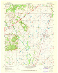 1969 Adair1971 Print · USGSMayes County at the end of the sixties shows a landscape of prairie hills and growing transit corridors. Genealogists and local historians can trace the community through Adair, Pleasant Hope Ch, and the landmark Jesse James Hill.
End of results
Showing maps 1-2 of 2
Top cities near Patton
- Claremore historical maps
- Pryor Creek historical maps
- Vinita historical maps
- Chelsea historical maps
- Salina historical maps
- Adair historical maps
See more
Frequently asked questions
- What are the different types of historical maps available for Patton?
- What is the oldest map of Patton?
- Where can I purchase historical maps of Patton for my home or office?
- Where can I download high-res historical maps of Patton?
- Are there historical topographic maps available for Patton?
- Is there historical aerial imagery available for Patton?
- Where are historical maps of Patton sourced from?