1900s (20th Century) Maps of Sportsmen Acres, Oklahoma
Explore 7 historic maps of Sportsmen Acres from the 1900s (20th Century). These maps offer a rare glimpse into what life looked like during the 1900s — showing old roads, neighborhoods, homes, and landmarks that have changed or disappeared over time.
Whether you're researching your family's past, planning a metal detecting trip, or studying how Sportsmen Acres's landscape evolved across the 1900s, these high-resolution maps are a powerful tool for exploring the history of this region.
- Focus on a specific era: All maps on this page are from the 1900s, giving you a focused view of this time period.
- See what’s changed: Compare century-old streets, trails, and buildings to today's modern landscape using overlays and satellite layers.
- Research with precision: Use these maps for genealogy, historical research, land use analysis, or educational projects.
- View, download, or print: Maps are fully viewable online in high resolution, and can be downloaded or printed for your own records.
Start exploring Sportsmen Acres's history through authentic maps from the 1900s. This is your window into the past.
Sportsmen Acres, OK maps
(7)- 1901 Map of Pryor
 1901 Pryor1901 Print · USGSIndian Territory at the turn of the century shows a landscape transitioning from tribal lands to a rail-connected frontier. Genealogists and historians can trace early river crossings like Markham Ferry and Dirteater Ford alongside frontier settlements like Choteau and Bushyhead.5 unique versions available
 - 1954 Map of Tulsa
 1954 Tulsa1954 Print · USGSNortheast Oklahoma and the Ozark border are shown here during a period of massive industrial and infrastructure growth. Researchers can trace the legacy of the Tri-State Mining District and the development of major reservoirs like Grand Lake O' The Cherokees.2 unique versions available
 - 1958 Map of Tulsa, 1968 Print
 1958 Tulsa1968 Print · USGSNortheast Oklahoma and the Ozark borderlands are captured here during a massive era of reservoir construction and highway expansion. Researchers can trace the mid-century footprints of Tulsa, the sprawling Lake O' the Cherokees, and historical sites like Pea Ridge National Military Park.3 unique versions available
 - 1963 Map of Tulsa
 1963 Tulsa1963 Print · USGSThe Oklahoma and Arkansas borderlands are shown here in the early sixties, a time of massive reservoir construction and heavy mining. Genealogists can trace family roots through settlements like Nowata, Pryor, and Jay, or locate historical zinc and lead mines and coal mines.
 - 1970 Map of Chouteau, 1972 Print
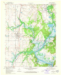 1970 Chouteau1972 Print · USGSMayes County in the early seventies shows a landscape defined by the arrival of heavy industry and the winding waters of the Neosho. Researchers can trace family sites like Sixkiller Cem and Lusta or explore the recreational shoreline at Mission Bend Public Use Area.4 unique versions available
 - 1972 Map of Locust Grove, 1974 Print
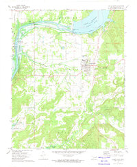 1972 Locust Grove1974 Print · USGSLocust Grove and the Neosho River valley are captured in the early seventies during a period of significant hydroelectric and industrial development. Researchers can trace family sites like Hogan Cem and Haner Cem alongside the Old Railroad Grade.2 unique versions available
 - 1985 Map of Tulsa
 1985 Tulsa1985 Print · USGSNortheastern Oklahoma in the mid-eighties shows a landscape shaped by massive reservoirs and a bustling transportation network. Researchers can trace the path of the Will Rogers Turnpike or locate local landmarks like Mohawk Park and Oologah Lake.2 unique versions available
End of results
Showing maps 1-7 of 7
Top cities near Sportsmen Acres
- Claremore historical maps
- Pryor Creek historical maps
- Chouteau historical maps
- Locust Grove historical maps
- Salina historical maps
- Adair historical maps
See more
Frequently asked questions
- What are the different types of historical maps available for Sportsmen Acres?
- What is the oldest map of Sportsmen Acres?
- Where can I purchase historical maps of Sportsmen Acres for my home or office?
- Where can I download high-res historical maps of Sportsmen Acres?
- Are there historical topographic maps available for Sportsmen Acres?
- Is there historical aerial imagery available for Sportsmen Acres?
- Where are historical maps of Sportsmen Acres sourced from?