1970s Maps of Webbers Falls, Oklahoma
Explore 7 historic maps of Webbers Falls from the 1970s. These maps offer a rare glimpse into what life looked like during the 1970s — showing old roads, neighborhoods, homes, and landmarks that have changed or disappeared over time.
Whether you're researching your family's past, planning a metal detecting trip, or studying how Webbers Falls's landscape evolved across the 1970s, these high-resolution maps are a powerful tool for exploring the history of this region.
- Focus on a specific era: All maps on this page are from the 1970s, giving you a focused view of this time period.
- See what’s changed: Compare century-old streets, trails, and buildings to today's modern landscape using overlays and satellite layers.
- Research with precision: Use these maps for genealogy, historical research, land use analysis, or educational projects.
- View, download, or print: Maps are fully viewable online in high resolution, and can be downloaded or printed for your own records.
Start exploring Webbers Falls's history through authentic maps from the 1970s. This is your window into the past.
Webbers Falls, OK maps
(7)- 1972 Map of Webbers Falls SE, 1974 Print
 1972 Webbers Falls SE1974 Print · USGSSequoyah County during the early seventies is revealed in sharp photographic detail, showing the developed landscape around the confluence of major waterways. Researchers can trace the path of the Illinois River past Gore to the Arkansas River and study the structural footprint of the Tenkiller Ferry Dam.
 - 1972 Map of Webbers Falls SW, 1974 Print
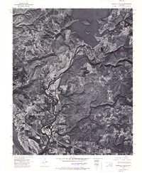
 1972 Webbers Falls SW1974 Print · USGSThe Arkansas River valley of eastern Oklahoma is seen here in the early seventies, just as new infrastructure transformed the landscape. Trace the footprint of Webbers Falls and the engineering of the Webbers Falls Dam and its reservoir.
 - 1974 Map of Gore, 1978 Print
 1974 Gore1978 Print · USGSGore and the surrounding Illinois River valley are shown in the mid-seventies just as the regional reservoir system was fully established. Researchers can trace family roots through numerous sites like Stevenson Cem, Notichtown Cem, and the Gum Spring Ch.2 unique versions available
 - 1974 Map of Webbers Falls, 1978 Print
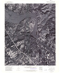
 1974 Webbers Falls1978 Print · USGSThe river-and-rail landscape of Webbers Falls is shown here in the mid-1970s, as the Arkansas River reservoirs reached their modern levels. Researchers can trace family sites at Phillips Cem and Mountain Grove Ch or locate the Webbers Falls Lock and Dam.
 - 1978 Map of Eufaula, 1979 Print
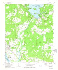
 1978 Eufaula1979 Print · USGSEastern Oklahoma in the late seventies is defined by the sprawling waters of Eufaula Lake and the dense timber of the Sans Bois Mountains. Genealogists and historians can trace the development of towns like Checotah and Stigler or locate legacy sites like the Old R R Grade and Robbers Cave State Park.
 - 1978 Map of Muskogee, 1979 Print
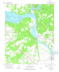
 1978 Muskogee1979 Print · USGSThe confluence of the Arkansas, Verdigris, and Neosho Rivers defines the Muskogee region in the late seventies. Genealogists and historians can trace the footprints of Camp Gruber (Abandoned), the campus of Bacone College, and early aviation at Hatbox Field.
 - 1978 Map of Fort Smith, 1979 Print
 1978 Fort Smith1979 Print · USGSThe Arkansas-Oklahoma borderlands in the late seventies show a landscape shaped by massive river reservoirs and sprawling military reservations. Trace the historic rail lines of the Missouri Pacific RR and locate regional landmarks like Fort Gibson, Tenkiller Ferry Lake, and Barling.2 unique versions available
End of results
Showing maps 1-7 of 7
Top cities near Webbers Falls
- Muskogee historical maps
- Vian historical maps
- Vian historical maps
- Warner historical maps
- Gore historical maps
- Porum historical maps
See more
Frequently asked questions
- What are the different types of historical maps available for Webbers Falls?
- What is the oldest map of Webbers Falls?
- Where can I purchase historical maps of Webbers Falls for my home or office?
- Where can I download high-res historical maps of Webbers Falls?
- Are there historical topographic maps available for Webbers Falls?
- Is there historical aerial imagery available for Webbers Falls?
- Where are historical maps of Webbers Falls sourced from?