1900s (20th Century) Maps of Nelagoney, Oklahoma
Explore 7 historic maps of Nelagoney from the 1900s (20th Century). These maps offer a rare glimpse into what life looked like during the 1900s — showing old roads, neighborhoods, homes, and landmarks that have changed or disappeared over time.
Whether you're researching your family's past, planning a metal detecting trip, or studying how Nelagoney's landscape evolved across the 1900s, these high-resolution maps are a powerful tool for exploring the history of this region.
- Focus on a specific era: All maps on this page are from the 1900s, giving you a focused view of this time period.
- See what’s changed: Compare century-old streets, trails, and buildings to today's modern landscape using overlays and satellite layers.
- Research with precision: Use these maps for genealogy, historical research, land use analysis, or educational projects.
- View, download, or print: Maps are fully viewable online in high resolution, and can be downloaded or printed for your own records.
Start exploring Nelagoney's history through authentic maps from the 1900s. This is your window into the past.
Nelagoney, OK maps
(7)- 1906 Map of Nelagoney, 1975 Print
 1906 Nelagoney1975 Print · USGSOsage County is captured here during a mid-century era of petroleum production and rail transit. Researchers can trace the routes of the Missouri Kansas Texas railroad and locate small stops like Okesa, Kiheki, and the Boy Scout Camp.
 - 1909 Map of Pawhuska, 1957 Print
 1909 Pawhuska1957 Print · USGSOsage County comes alive in this turn-of-the-century survey of the terrain around Pawhuska and its neighboring rail towns. Trace the paths of three major railroads as they pass through Barnsdall, find landmarks like Daltons Caves, or locate the White Swan Ford.
 - 1910 Map of Pawhuska
 1910 Pawhuska1910 Print · USGSOsage County's landscape at the dawn of Oklahoma statehood reveals a transition from tribal lands to a rail-connected economy. Genealogists and historians can trace early settlements like Wynona and Bigheart, or find local landmarks like Daltons Caves and White Swan Ford.2 unique versions available
 - 1955 Map of Enid, 1966 Print
 1955 Enid1966 Print · USGSNorth-central Oklahoma's transition from open plains to the blackjack hills of the Osage Indian Reservation is captured in the mid-1950s. Researchers can trace the development of the Naval Reserve Oil Field, the grounds of Vance AFB, and the early footprints of Tulsa and Stillwater.4 unique versions available
 - 1958 Map of Enid
 1958 Enid1958 Print · USGSNorthern Oklahoma is mapped here in the late fifties, showcasing a dense network of petroleum production and historic tribal lands. Researchers can trace the legacy of the Osage Indian Reservation, early energy hubs like the Cushing Oil Field, and the Chilocco Indian Agricultural School.2 unique versions available
 - 1960 Map of Nelagoney, 1961 Print
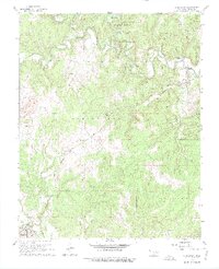
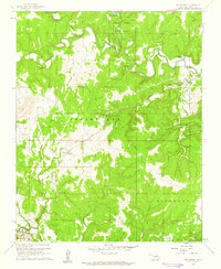 1960 Nelagoney1961 Print · USGSThe Osage Hills at the start of the sixties were a landscape defined by petroleum production and quiet creek valleys. Local historians can trace the paths of the Missouri Kansas Texas railroad through Okesa and identify oil wells across Strike Axe.2 unique versions available
 - 1985 Map of Pawhuska, 1986 Print
 1985 Pawhuska1986 Print · USGSThe Osage Indian Reservation and its tribal capital at Pawhuska are seen here in the mid-1980s as the region's ranching and oil legacies matured. Genealogists and historians can trace family-named sites and vanished industrial tracks near Bigheart, Wynona, and Gray Horse.2 unique versions available
End of results
Showing maps 1-7 of 7
Top cities near Nelagoney
- Skiatook historical maps
- Pawhuska historical maps
- Hominy historical maps
- Barnsdall historical maps
- Wynona historical maps
- Avant historical maps
Frequently asked questions
- What are the different types of historical maps available for Nelagoney?
- What is the oldest map of Nelagoney?
- Where can I purchase historical maps of Nelagoney for my home or office?
- Where can I download high-res historical maps of Nelagoney?
- Are there historical topographic maps available for Nelagoney?
- Is there historical aerial imagery available for Nelagoney?
- Where are historical maps of Nelagoney sourced from?