Old Maps of Owasso, Oklahoma for Genealogy
Trace your family roots with 13 historic maps of Owasso. These high-res maps reveal old neighborhoods, homesites, landmarks, and streets — helping you uncover where your ancestors lived and how the area evolved over time.
- Explore historic neighborhoods: Identify where your relatives may have lived in the 1800s or 1900s.
- Compare maps over time: Trace the changes in streets, buildings, and landmarks for multi-generational research.
- Perfect for genealogy & ancestry research: Used by family historians and researchers to map out lineage and migration.
These maps are an incredible resource for exploring your personal connection to Owasso's past.
Owasso, OK maps
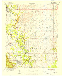
(13)- 1901 Map of Claremore
 1901 Claremore1901 Print · USGSCovers Owasso, including Tulsa, Broken Arrow, and other nearby areas4 unique versions available
 - 1914 Map of Claremore, 1959 Print
 1914 Claremore1959 Print · USGSCovers Owasso, including Tulsa, Broken Arrow, and other nearby areas
 - 1916 Map of Claremore
 1916 Claremore1916 Print · USGSCovers Owasso, including Tulsa, Broken Arrow, and other nearby areas4 unique versions available
 - 1954 Map of Tulsa
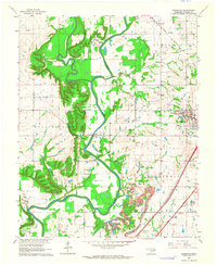
 1954 Tulsa1954 Print · USGSCovers Owasso, including Tulsa, Broken Arrow, and other nearby areas2 unique versions available
 - 1954 Map of Tulsa, 1955 Print
 1954 Tulsa1955 Print · USGSCovers Owasso, including Tulsa, Turley, and other nearby areas5 unique versions available
 - 1955 Map of Sperry, 1956 Print
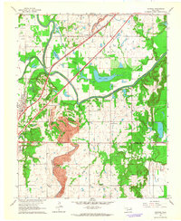
 1955 Sperry1956 Print · USGSCovers Owasso, including Tulsa, Skiatook, and other nearby areas3 unique versions available
 - 1955 Map of Mingo, 1956 Print
 1955 Mingo1956 Print · USGSCovers Owasso, including Tulsa, Catoosa, and other nearby areas4 unique versions available
 - 1956 Map of Collinsville, 1957 Print
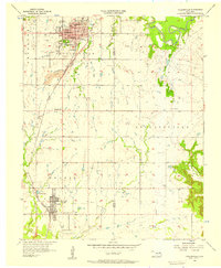 1956 Collinsville1957 Print · USGSCovers Owasso, including Collinsville, Valley Park, and other nearby areas3 unique versions available
 - 1958 Map of Tulsa, 1968 Print
 1958 Tulsa1968 Print · USGSCovers Owasso, including Tulsa, Broken Arrow, and other nearby areas3 unique versions available
 - 1963 Map of Tulsa
 1963 Tulsa1963 Print · USGSCovers Owasso, including Tulsa, Broken Arrow, and other nearby areas
 - 1963 Map of Sageeyah, 1964 Print
 1963 Sageeyah1964 Print · USGSCovers Owasso, including Claremore, Verdigris, and other nearby areas3 unique versions available
 - 1963 Map of Catoosa, 1964 Print
 1963 Catoosa1964 Print · USGSCovers Owasso, including Tulsa, Catoosa, and other nearby areas4 unique versions available
 - 1985 Map of Tulsa
 1985 Tulsa1985 Print · USGSCovers Owasso, including Tulsa, Broken Arrow, and other nearby areas2 unique versions available
End of results
Showing maps 1-13 of 13
Top cities near Owasso
- Tulsa historical maps
- Sapulpa historical maps
- Claremore historical maps
- Skiatook historical maps
- Catoosa historical maps
- Collinsville historical maps
See more
Top neighborhoods of Owasso
- Baptist Village historical maps
- Country Estates historical maps
- Crescent Ridge historical maps
- The Falls at Garrett Creek historical maps
- The Lakes at Bailey Ranch historical maps
Frequently asked questions
- What are the different types of historical maps available for Owasso?
- What is the oldest map of Owasso?
- Where can I purchase historical maps of Owasso for my home or office?
- Where can I download high-res historical maps of Owasso?
- Are there historical topographic maps available for Owasso?
- Is there historical aerial imagery available for Owasso?
- Where are historical maps of Owasso sourced from?