1900s (20th Century) Maps of Payne County, Oklahoma
Explore 37 historic maps of Payne County from the 1900s (20th Century). These maps offer a rare glimpse into what life looked like during the 1900s — showing old roads, neighborhoods, homes, and landmarks that have changed or disappeared over time.
Whether you're researching your family's past, planning a metal detecting trip, or studying how Payne County's landscape evolved across the 1900s, these high-resolution maps are a powerful tool for exploring the history of this region.
- Focus on a specific era: All maps on this page are from the 1900s, giving you a focused view of this time period.
- See what’s changed: Compare century-old streets, trails, and buildings to today's modern landscape using overlays and satellite layers.
- Research with precision: Use these maps for genealogy, historical research, land use analysis, or educational projects.
- View, download, or print: Maps are fully viewable online in high resolution, and can be downloaded or printed for your own records.
Start exploring Payne County's history through authentic maps from the 1900s. This is your window into the past.
Payne County, OK maps
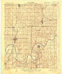
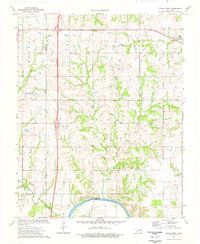
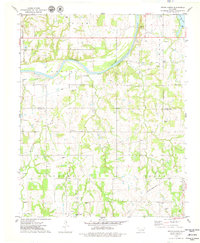
(37)- 1908 Map of Agra
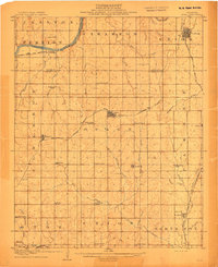 1908 Agra1908 Print · USGSAs the Oklahoma Territory transitioned into statehood, this area was a bustling network of new rail lines and rural school districts. Researchers can trace early township developments and family-centric landmarks like Free Silver School, the riverside stop at Cottingham, or the junction at Agra.3 unique versions available
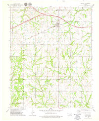
 - 1909 Map of Perkins
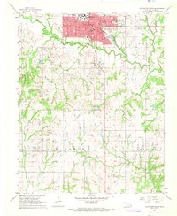
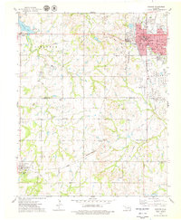
 1909 Perkins1909 Print · USGSOklahoma Territory near the turn of the century is a landscape of new rail-side towns and scattered one-room schoolhouses. Genealogists and historians can trace family roots through dozens of named sites like Vim PO, Mt Bethel Church, and Eagle College School.4 unique versions available
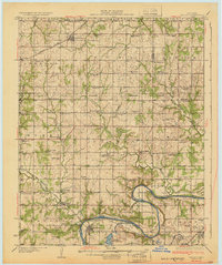
 - 1929 Map of Yale, 1959 Print
 1929 Yale1959 Print · USGSOklahoma's oil and rail heartland comes into focus in the late 1920s as the petroleum industry reshapes the landscape of the former Indian Territory. Researchers can trace the extensive network of rural schools and industrial sites, from 35 Oil Tanks near Oilton to the many country schoolhouses like Lone Elm Sch and Bethel Sch.
 - 1929 Map of Ripley, 1959 Print
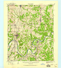
 1929 Ripley1959 Print · USGSEastern Oklahoma townships in Payne and Pawnee Counties appear here as they were in the late 1920s, structured by early rail lines and river bends. You can trace the community life of the era through sites like Ingalls Signet P O, the Rosenwald Sch, and the Atchison Topeka and Santa Fe tracks.
 - 1931 Map of Drumright
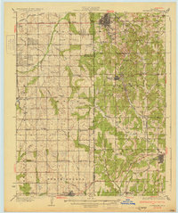 1931 Drumright1931 Print · USGSOklahoma's oil boom era is captured here at its peak, showing the industrial landscape around Drumright and Shamrock. Local historians can trace dozens of rural school sites like Happy Valley Sch and the original path of Highway No 66.4 unique versions available
 - 1932 Map of Yale
 1932 Yale1932 Print · USGSThe oil-rich landscape along the Cimarron River is captured here just after the peak of the regional boom. Researchers can locate early schools and burial sites like Pleasantvale Sch and Greenwood Cem, alongside major petroleum infrastructure like the 35 Oil Tanks near Oilton.3 unique versions available
 - 1932 Map of Ripley
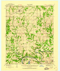
 1932 Ripley1932 Print · USGSRipley and Glencoe anchor this Depression-era portrait of the Oklahoma landscape as the oil industry began to mark the riverbanks. Researchers can locate dozens of vanished rural schools and early landmarks like Twin Mounds, the Payne County Farm, and the Signet PO.2 unique versions available
 - 1954 Map of Oklahoma City
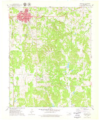
 1954 Oklahoma City1954 Print · USGSOklahoma City and its surrounding counties are captured here in the early fifties during a period of significant postwar growth. Researchers can trace the development of the Turner Turnpike and locate aviation hubs like Tinker Field or Will Rogers Field.
 - 1955 Map of Enid, 1966 Print
 1955 Enid1966 Print · USGSNorth-central Oklahoma's transition from open plains to the blackjack hills of the Osage Indian Reservation is captured in the mid-1950s. Researchers can trace the development of the Naval Reserve Oil Field, the grounds of Vance AFB, and the early footprints of Tulsa and Stillwater.4 unique versions available
 - 1957 Map of Oklahoma City, 1969 Print
 1957 Oklahoma City1969 Print · USGSCentral Oklahoma is captured here in a period of significant mid-century growth and industrialization. Researchers can trace family roots through numerous rural markers like Memory Lane Cem, New Hope School, and the sprawling grounds of Tinker Air Force Base.3 unique versions available
 - 1958 Map of Enid
 1958 Enid1958 Print · USGSNorthern Oklahoma is mapped here in the late fifties, showcasing a dense network of petroleum production and historic tribal lands. Researchers can trace the legacy of the Osage Indian Reservation, early energy hubs like the Cushing Oil Field, and the Chilocco Indian Agricultural School.2 unique versions available
 - 1963 Map of Oklahoma City
 1963 Oklahoma City1963 Print · USGSCentral Oklahoma in the early sixties showcases a landscape of rapid suburban growth and established oil production. Researchers can trace historic rail lines like the Chicago Rock Island and Pacific RR or locate rural landmarks such as Mayflower School and Bethel Church.
 - 1966 Map of Lake Carl Blackwell, 1968 Print
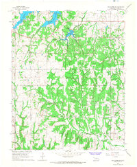
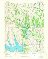 1966 Lake Carl Blackwell1968 Print · USGSNoble and Payne Counties undergo a major landscape shift in the mid-sixties as new reservoirs reshape the central Oklahoma terrain. Researchers can find family landmarks like Shelton-Bethel Cem and industrial sites such as the Rock Creek Oil Field.3 unique versions available
 - 1967 Map of Stillwater North, 1968 Print
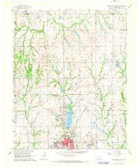 1967 Stillwater North1968 Print · USGSStillwater and its northern reaches are captured in the late sixties as the university and city began significant expansion. Researchers can trace the development of Oklahoma State University and the grounds of Boomer Lake Park or the settlement at Yost.3 unique versions available
 - 1967 Map of Stillwater South, 1968 Print
 1967 Stillwater South1968 Print · USGSStillwater was expanding southward in the late 1960s as university growth and the oil industry shaped the local economy. Researchers can trace rural lineages through sites like Elm Grove Cem, United Brethren Ch, and the Lost Creek Oil Field.2 unique versions available
 - 1967 Map of Stillwater SW, 1968 Print
 1967 Stillwater SW1968 Print · USGSSouthwest of Stillwater in the late sixties, the landscape reflects a busy intersection of petroleum production and rural life. Genealogists and historians can trace old homesteads and church sites like Paradise Ch and burial grounds including Marena Cem and Mt Vernon Cem.3 unique versions available
 - 1970 Map of Langston, 1972 Print
 1970 Langston1972 Print · USGSThe Oklahoma countryside near the Logan and Payne county line is captured here just as the landscape was being reshaped by the Langston Dam Under Constr. Researchers can locate Langston University, several family-named community halls, and numerous cemeteries like Mt Hope Cem and Holy Family Cem.3 unique versions available
 - 1974 Map of Orlando East, 1977 Print
 1974 Orlando East1977 Print · USGSNear the intersection of Noble, Logan, and Payne counties in the mid-1970s, this area reflects a landscape shaped by oil production and rail transport. Genealogists and historians can trace Orlando and Fairview Cem alongside the Atchison Topeka and Santa Fe tracks.
 - 1974 Map of Clear Creek, 1977 Print
 1974 Clear Creek1977 Print · USGSThe rural border of Logan and Payne counties comes alive in the mid-seventies as an active extraction zone. Trace family history at Morris Heights Cem or follow the waters of the Cimarron River and Clear Creek.
 - 1975 Map of Cushing, 1979 Print
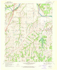
 1975 Cushing1979 Print · USGSCushing and the surrounding Central Oklahoma oil country are captured here during the mid-seventies, showing the intersection of heavy industry and rural life. Genealogists and local historians can trace family locations near Union Cem, Avery, and the Lone Oak Community Hall.
 - 1975 Map of West Point, 1979 Print
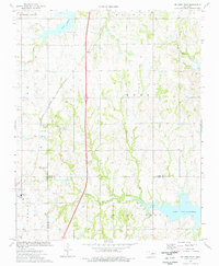
 1975 West Point1979 Print · USGSNorth-central Oklahoma's oil-rich landscape comes into focus in the mid-1970s, where traditional boundaries meet modern industry. Researchers can trace family history at Mt Vernon Cem and Hopp Cem or locate old lease sites across the Oil Field.
 - 1975 Map of Drumright, 1979 Print
 1975 Drumright1979 Print · USGSOklahoma's oil country is captured in the mid-seventies, showing the developed landscapes of the Shannon Oil Field and the grid of Drumright. Genealogists and historians can trace the Indian Territory Oklahoma Boundary and locate the Shamrock Cem or the Old Railroad Grade.
 - 1975 Map of Tryon North, 1979 Print
 1975 Tryon North1979 Print · USGSCentral Oklahoma's river valley comes alive in the mid-seventies, showing the intersection of rural agriculture and the oil industry. Genealogists can locate several burial sites including the Iowa Indian Cem and Oakdale Cem, while tracing the path of the Missouri - Kansas - Texas railroad.
 - 1975 Map of North Village, 1979 Print
 1975 North Village1979 Print · USGSThe Oklahoma oil country east of Cushing comes into focus during the mid-seventies, revealing a landscape of heavy industry and quiet rural settlements. Researchers can trace the legacy of petroleum through several Tank Farms or locate family roots at Silver Star Cem and Harmony Sch.
 - 1975 Map of Glencoe, 1979 Print
 1975 Glencoe1979 Print · USGSThe crossroads of Glencoe and the surrounding prairie are captured here in the mid-seventies, just as the local energy and transit networks were maturing. Genealogists and historians can trace family plots at Glencoe Cem and Bethel Cem or locate the historic Old Indian Treaty Boundary.
Showing maps 1-25 of 37
Top cities of Payne County
- Stillwater historical maps
- Cushing historical maps
- Perkins historical maps
- Yale historical maps
- Glencoe historical maps
- Ripley historical maps
Frequently asked questions
- What are the different types of historical maps available for Payne County?
- What is the oldest map of Payne County?
- Where can I purchase historical maps of Payne County for my home or office?
- Where can I download high-res historical maps of Payne County?
- Are there historical topographic maps available for Payne County?
- Is there historical aerial imagery available for Payne County?
- Where are historical maps of Payne County sourced from?