1900s (20th Century) Maps of McAlester, Oklahoma
Explore 8 historic maps of McAlester from the 1900s (20th Century). These maps offer a rare glimpse into what life looked like during the 1900s — showing old roads, neighborhoods, homes, and landmarks that have changed or disappeared over time.
Whether you're researching your family's past, planning a metal detecting trip, or studying how McAlester's landscape evolved across the 1900s, these high-resolution maps are a powerful tool for exploring the history of this region.
- Focus on a specific era: All maps on this page are from the 1900s, giving you a focused view of this time period.
- See what’s changed: Compare century-old streets, trails, and buildings to today's modern landscape using overlays and satellite layers.
- Research with precision: Use these maps for genealogy, historical research, land use analysis, or educational projects.
- View, download, or print: Maps are fully viewable online in high resolution, and can be downloaded or printed for your own records.
Start exploring McAlester's history through authentic maps from the 1900s. This is your window into the past.
McAlester, OK maps
(8)- 1909 Map of Mc Alester
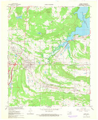
 1909 Mc Alester1909 Print · USGSSoutheast Oklahoma's coal mining belt and the rugged Choctaw Nation territory are captured here in the early years of statehood. Researchers can trace the rail-side growth of McAlester and Hartshorne or locate vanished sites like Barnett Sta Haywood PO and Perryville.3 unique versions available
 - 1950 Map of Mcalester
 1950 Mcalester1950 Print · USGSThe Ouachita Mountains and the coal country of Southeast Oklahoma are shown here in the late 1940s. Genealogists and historians can trace the rail-driven growth of McAlester, Wilburton, and Antlers alongside the rugged terrain of Kiamichi Mountain.2 unique versions available
 - 1962 Map of McAlester
 1962 McAlester1962 Print · USGSSoutheastern Oklahoma and western Arkansas are shown here during the early sixties, a time of transition for the region's mountain communities and timberlands. Researchers can trace the paths of the Kansas City Southern RR through Heavener or locate settlements like Talihina and Broken Bow near the Kiamichi Mountains.2 unique versions available
 - 1965 Map of McAlester
 1965 McAlester1965 Print · USGSSoutheastern Oklahoma and western Arkansas appear here in the mid-1960s, showing the intersection of the timber industry and the growing reservoir system. Genealogists can trace family roots through settlements like Antlers, Idabel, and Kiowa or follow the historic routes of the Kansas City Southern Ry.3 unique versions available
 - 1967 Map of Krebs, 1968 Print
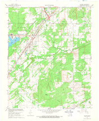
 1967 Krebs1968 Print · USGSThe coal and rail corridors of Pittsburg County are meticulously detailed here in the late sixties. Genealogists and local historians can trace family roots through Oak Hill Cemetery, locate the L'Ouverture Sch, or follow the lines of the Missouri Kansas Texas railroad.2 unique versions available
 - 1967 Map of Mc Alester, 1968 Print
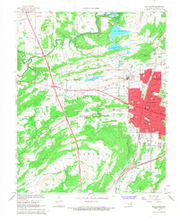 1967 Mc Alester1968 Print · USGSMcAlester and its surrounding prairies appear here in the late sixties, showing a city deeply shaped by its rail junctions and correctional facilities. Genealogists and local historians can trace family-named sites like Tannehill Cem, locate old schoolhouses such as Frink-Chambers Sch, and explore the layout of the State Penitentiary.3 unique versions available
 - 1967 Map of Savanna, 1968 Print
 1967 Savanna1968 Print · USGSSoutheast Oklahoma in the late sixties reveals a landscape shaped by military logistics and rail history. Trace the operations of the U S Naval Ammunition Depot and the paths of the Missouri-Kansas-Texas line through Savanna and Blanco.3 unique versions available
 - 1991 Map of Mc Alester
 1991 Mc Alester1991 Print · USGSSoutheastern Oklahoma’s coal and rail corridor is captured here during the early nineties, centered on the regional hub of McAlester. Local historians can trace the development of towns along the Missouri-Kansas-Texas RR and find landmarks like Sardis Lake and the State Penitentiary.
End of results
Showing maps 1-8 of 8
Top cities near McAlester
- Krebs historical maps
- Hartshorne historical maps
- Haileyville historical maps
- Savanna historical maps
- Kiowa historical maps
- Crowder historical maps
See more
Top neighborhoods of McAlester
Frequently asked questions
- What are the different types of historical maps available for McAlester?
- What is the oldest map of McAlester?
- Where can I purchase historical maps of McAlester for my home or office?
- Where can I download high-res historical maps of McAlester?
- Are there historical topographic maps available for McAlester?
- Is there historical aerial imagery available for McAlester?
- Where are historical maps of McAlester sourced from?