1960s Maps of Quinton, Oklahoma
Explore 6 historic maps of Quinton from the 1960s. These maps offer a rare glimpse into what life looked like during the 1960s — showing old roads, neighborhoods, homes, and landmarks that have changed or disappeared over time.
Whether you're researching your family's past, planning a metal detecting trip, or studying how Quinton's landscape evolved across the 1960s, these high-resolution maps are a powerful tool for exploring the history of this region.
- Focus on a specific era: All maps on this page are from the 1960s, giving you a focused view of this time period.
- See what’s changed: Compare century-old streets, trails, and buildings to today's modern landscape using overlays and satellite layers.
- Research with precision: Use these maps for genealogy, historical research, land use analysis, or educational projects.
- View, download, or print: Maps are fully viewable online in high resolution, and can be downloaded or printed for your own records.
Start exploring Quinton's history through authentic maps from the 1960s. This is your window into the past.
Quinton, OK maps
(6)- 1965 Map of Fort Smith
 1965 Fort Smith1965 Print · USGSEastern Oklahoma and Western Arkansas are captured here during a period of massive post-war change as new reservoirs reshaped the river valleys. Genealogists and historians can trace the rail networks of the Midland Valley RR and find established communities like Stilwell, Sallisaw, and Stigler.
 - 1967 Map of Fort Smith
 1967 Fort Smith1967 Print · USGSThe Arkansas River valley and the foothills of the Ozarks are captured here during a period of significant military and industrial activity. Researchers can trace the sprawling bounds of Camp Chaffee and Camp Gruber or locate vanished rail stops along the Midland Valley RR.
 - 1969 Map of Quinton North, 1971 Print
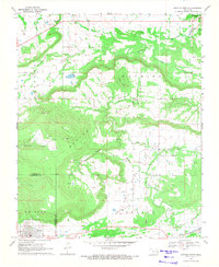 1969 Quinton North1971 Print · USGSEastern Oklahoma's ridge-and-valley landscape is captured here during the late 1960s, showing the intersection of rural life and early energy development. Researchers can trace family sites at Quinton Cem and Mountain Home Cem or locate industrial markers like the Strip Mine and Ware Farm Landing Field.3 unique versions available
 - 1969 Map of Featherston, 1971 Print
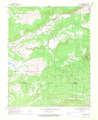 1969 Featherston1971 Print · USGSThe Pittsburg and Latimer county line ran through the heart of the gas-rich hills in the late 1960s. Genealogists and historians can trace local landmarks like Featherston Cem, Bascom Ch, and the extensive energy works of the Quinton Gas Field.2 unique versions available
 - 1969 Map of Quinton South, 1971 Print
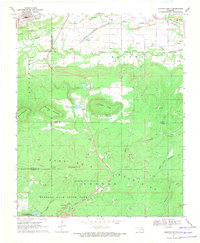 1969 Quinton South1971 Print · USGSThe San Bois Mountains of southeast Oklahoma are captured here in the late sixties as the region balanced mining and recreation. Genealogists and historians can trace the Lewisville Cem, follow an Old Railroad Grade, or explore the early layout of Robbers Cave State Park.4 unique versions available
 - 1969 Map of Enterprise, 1971 Print
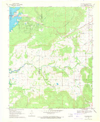 1969 Enterprise1971 Print · USGSHaskell and Pittsburg counties are captured here in the late sixties as the rising waters of Eufaula Reservoir reshaped the shoreline. Genealogists and local historians can locate Enterprise and Russellville, alongside Enterprise Cem and Oak Ridge Ch.2 unique versions available
End of results
Showing maps 1-6 of 6
Top cities near Quinton
- Wilburton historical maps
- Eufaula historical maps
- Porum historical maps
- Kinta historical maps
- Whitefield historical maps
- Carlton Landing historical maps
Frequently asked questions
- What are the different types of historical maps available for Quinton?
- What is the oldest map of Quinton?
- Where can I purchase historical maps of Quinton for my home or office?
- Where can I download high-res historical maps of Quinton?
- Are there historical topographic maps available for Quinton?
- Is there historical aerial imagery available for Quinton?
- Where are historical maps of Quinton sourced from?