1970s Maps of Pottawatomie County, Oklahoma
Explore 3 historic maps of Pottawatomie County from the 1970s. These maps offer a rare glimpse into what life looked like during the 1970s — showing old roads, neighborhoods, homes, and landmarks that have changed or disappeared over time.
Whether you're researching your family's past, planning a metal detecting trip, or studying how Pottawatomie County's landscape evolved across the 1970s, these high-resolution maps are a powerful tool for exploring the history of this region.
- Focus on a specific era: All maps on this page are from the 1970s, giving you a focused view of this time period.
- See what’s changed: Compare century-old streets, trails, and buildings to today's modern landscape using overlays and satellite layers.
- Research with precision: Use these maps for genealogy, historical research, land use analysis, or educational projects.
- View, download, or print: Maps are fully viewable online in high resolution, and can be downloaded or printed for your own records.
Start exploring Pottawatomie County's history through authentic maps from the 1970s. This is your window into the past.
Pottawatomie County, OK maps
(3)- 1972 Map of Maud, 1974 Print
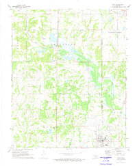 1972 Maud1974 Print · USGSThe Oklahoma oil patch near Maud is captured here in the early seventies as the petroleum and rail economy shaped the border between Pottawatomie and Seminole counties. Researchers can trace the Old Indian Treaty Boundary and locate family burial sites at Union Cems and Fairview Cem.
 - 1972 Map of St. Louis, 1974 Print
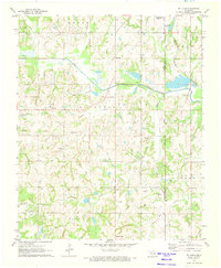 1972 St. Louis1974 Print · USGSCentral Oklahoma's petroleum landscape is captured here in the early seventies, spanning the border of Pottawatomie and Seminole counties. Trace the extensive St Louis Oil Field and find historic sites like Sacred Heart and Collins Cem.2 unique versions available
 - 1972 Map of Brooksville, 1974 Print
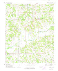 1972 Brooksville1974 Print · USGSPottawatomie County in the early seventies is a landscape of creek-fed valleys and quiet rural crossroads. Researchers can trace family history through sites like Brooksville Cem or locate the defunct Old Railroad Grade near the Little River.2 unique versions available
End of results
Showing maps 1-3 of 3
Top cities of Pottawatomie County
- Shawnee historical maps
- Tecumseh historical maps
- McLoud historical maps
- Bethel Acres historical maps
- Pink historical maps
- Earlsboro historical maps
See more
Frequently asked questions
- What are the different types of historical maps available for Pottawatomie County?
- What is the oldest map of Pottawatomie County?
- Where can I purchase historical maps of Pottawatomie County for my home or office?
- Where can I download high-res historical maps of Pottawatomie County?
- Are there historical topographic maps available for Pottawatomie County?
- Is there historical aerial imagery available for Pottawatomie County?
- Where are historical maps of Pottawatomie County sourced from?