1900s (20th Century) Maps of Tipton, Oklahoma
Explore 7 historic maps of Tipton from the 1900s (20th Century). These maps offer a rare glimpse into what life looked like during the 1900s — showing old roads, neighborhoods, homes, and landmarks that have changed or disappeared over time.
Whether you're researching your family's past, planning a metal detecting trip, or studying how Tipton's landscape evolved across the 1900s, these high-resolution maps are a powerful tool for exploring the history of this region.
- Focus on a specific era: All maps on this page are from the 1900s, giving you a focused view of this time period.
- See what’s changed: Compare century-old streets, trails, and buildings to today's modern landscape using overlays and satellite layers.
- Research with precision: Use these maps for genealogy, historical research, land use analysis, or educational projects.
- View, download, or print: Maps are fully viewable online in high resolution, and can be downloaded or printed for your own records.
Start exploring Tipton's history through authentic maps from the 1900s. This is your window into the past.
Tipton, OK maps
(7)- 1955 Map of Lawton, 1958 Print
 1955 Lawton1958 Print · USGSSouthwestern Oklahoma and North Texas are shown here in the mid-fifties, dominated by the Wichita Mountains and the vital Red River watershed. Genealogists and historians can trace the foundations of Lawton alongside rural landmarks like Rainy Mountain Church and Pleasant Hill School.5 unique versions available
 - 1958 Map of Frederick, 1959 Print
 1958 Frederick1959 Print · USGSAcross the Tillman County plains in the late fifties, the landscape was defined by the transition from agriculture to oil. Researchers can trace the rail corridors of the Missouri Kansas Texas or locate local centers like Middick Store and Tesca Ch.
 - 1964 Map of Tipton, 1965 Print
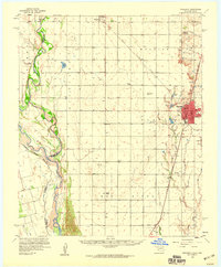
 1964 Tipton1965 Print · USGSOklahoma's southwestern plains come into focus in the mid-sixties, dominated by the winding course of the North Fork Red River. Genealogists and historians can trace the rail-side growth of Tipton, the Boucher Oil Field, and the site of a local Orphanage.2 unique versions available
 - 1975 Map of Frederick NW
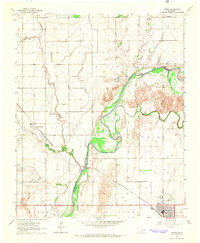
 1975 Frederick NW1975 Print · USGSOklahoma's agricultural heartland is documented in the mid-seventies, showing the intersection of the North Fork Red River and the grid of Tipton. Researchers can trace land use patterns near TIPTON and locate the natural waters of WHITE LAKE.
 - 1984 Map of White Lake, 1985 Print
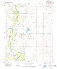 1984 White Lake1985 Print · USGSTipton and the surrounding Oklahoma plains are captured here in the mid-1980s, revealing a landscape of river-bend agriculture and early oil exploration. Genealogists and local historians can trace family land near Weaver Sch or follow the Missouri - Kansas - Texas rail line.
 - 1985 Map of Altus
 1985 Altus1985 Print · USGSSouthwestern Oklahoma in the mid-eighties shows a vast agricultural and military landscape shaped by the Red River forks. Trace the intersections of the Atchison Topeka and Santa Fe railroad with rural points like Fairmount Cem and Duke.2 unique versions available
 - 1986 Map of Vernon
 1986 Vernon1986 Print · USGSNorth Texas and Southern Oklahoma meet along the river in the mid-1980s, revealing a landscape defined by ranching, oil production, and rail transport. Researchers can locate distinct landmarks such as Medicine Mound, the Conley Oil Field, and the community of Punkin Center.
End of results
Showing maps 1-7 of 7
Top cities near Tipton
- Altus historical maps
- Frederick historical maps
- Snyder historical maps
- Mountain Park historical maps
- Manitou historical maps
- Headrick historical maps
See more
Frequently asked questions
- What are the different types of historical maps available for Tipton?
- What is the oldest map of Tipton?
- Where can I purchase historical maps of Tipton for my home or office?
- Where can I download high-res historical maps of Tipton?
- Are there historical topographic maps available for Tipton?
- Is there historical aerial imagery available for Tipton?
- Where are historical maps of Tipton sourced from?