1950s Maps of Sand Springs, Oklahoma
Explore 7 historic maps of Sand Springs from the 1950s. These maps offer a rare glimpse into what life looked like during the 1950s — showing old roads, neighborhoods, homes, and landmarks that have changed or disappeared over time.
Whether you're researching your family's past, planning a metal detecting trip, or studying how Sand Springs's landscape evolved across the 1950s, these high-resolution maps are a powerful tool for exploring the history of this region.
- Focus on a specific era: All maps on this page are from the 1950s, giving you a focused view of this time period.
- See what’s changed: Compare century-old streets, trails, and buildings to today's modern landscape using overlays and satellite layers.
- Research with precision: Use these maps for genealogy, historical research, land use analysis, or educational projects.
- View, download, or print: Maps are fully viewable online in high resolution, and can be downloaded or printed for your own records.
Start exploring Sand Springs's history through authentic maps from the 1950s. This is your window into the past.
Sand Springs, OK maps
(7)- 1955 Map of Enid, 1966 Print
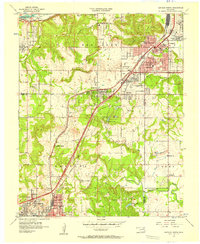
 1955 Enid1966 Print · USGSNorth-central Oklahoma's transition from open plains to the blackjack hills of the Osage Indian Reservation is captured in the mid-1950s. Researchers can trace the development of the Naval Reserve Oil Field, the grounds of Vance AFB, and the early footprints of Tulsa and Stillwater.4 unique versions available
 - 1956 Map of Sand Springs, 1957 Print
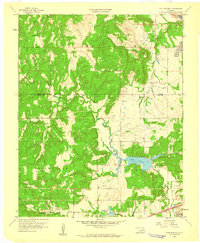
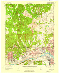 1956 Sand Springs1957 Print · USGSThe industrial corridor along the Arkansas River comes to life in this mid-century survey of the Tulsa and Sand Springs area. Researchers can trace the extensive Oil Field networks, the massive Oil Refinery, and dozens of local landmarks like Woodland Cemetery and the Tulsa North Airport.6 unique versions available
 - 1956 Map of Sapulpa North, 1957 Print
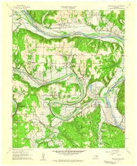
 1956 Sapulpa North1957 Print · USGSSapulpa and southwest Tulsa are caught in a period of industrial and suburban expansion during the mid-fifties. Researchers can trace the path of the Tulsa Sapulpa Union railroad past legacy sites like Little Cussetah Ch, Bowden, and the Oil Refinery.4 unique versions available
 - 1958 Map of Enid
 1958 Enid1958 Print · USGSNorthern Oklahoma is mapped here in the late fifties, showcasing a dense network of petroleum production and historic tribal lands. Researchers can trace the legacy of the Osage Indian Reservation, early energy hubs like the Cushing Oil Field, and the Chilocco Indian Agricultural School.2 unique versions available
 - 1958 Map of Keystone Dam, 1959 Print
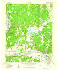
 1958 Keystone Dam1959 Print · USGSOklahoma's river valleys underwent a massive transformation in the late fifties as the Keystone Dam Under Construction project began. Researchers can trace the original locations of Prue, Appalachia, and Keystone along with family-named sites like Dixie Cem.4 unique versions available
 - 1958 Map of Wekiwa, 1959 Print
 1958 Wekiwa1959 Print · USGSThe Arkansas River valley of the late 1950s was a landscape defined by the Osage Indian Reservation, heavy oil production, and vital rail lines. Genealogists and local historians can trace the foundations of Fisher and Wekiwa, along with rural landmarks like Anderson Sch and Fisher Ch.5 unique versions available
 - 1959 Map of Lake Sahoma, 1960 Print
 1959 Lake Sahoma1960 Print · USGSCreek County at the close of the 1950s shows a landscape defined by the intersection of the burgeoning petroleum industry and rural community life. Trace the early development of the Turnpike Road (Toll) and locate historical sites like Pretty Water Sch and the Kellyville Oil Field.4 unique versions available
End of results
Showing maps 1-7 of 7
Top cities near Sand Springs
- Tulsa historical maps
- Bixby historical maps
- Sapulpa historical maps
- Jenks historical maps
- Glenpool historical maps
- Skiatook historical maps
See more
Top neighborhoods of Sand Springs
Frequently asked questions
- What are the different types of historical maps available for Sand Springs?
- What is the oldest map of Sand Springs?
- Where can I purchase historical maps of Sand Springs for my home or office?
- Where can I download high-res historical maps of Sand Springs?
- Are there historical topographic maps available for Sand Springs?
- Is there historical aerial imagery available for Sand Springs?
- Where are historical maps of Sand Springs sourced from?