1960s Maps of Wagoner County, Oklahoma
Explore 10 historic maps of Wagoner County from the 1960s. These maps offer a rare glimpse into what life looked like during the 1960s — showing old roads, neighborhoods, homes, and landmarks that have changed or disappeared over time.
Whether you're researching your family's past, planning a metal detecting trip, or studying how Wagoner County's landscape evolved across the 1960s, these high-resolution maps are a powerful tool for exploring the history of this region.
- Focus on a specific era: All maps on this page are from the 1960s, giving you a focused view of this time period.
- See what’s changed: Compare century-old streets, trails, and buildings to today's modern landscape using overlays and satellite layers.
- Research with precision: Use these maps for genealogy, historical research, land use analysis, or educational projects.
- View, download, or print: Maps are fully viewable online in high resolution, and can be downloaded or printed for your own records.
Start exploring Wagoner County's history through authentic maps from the 1960s. This is your window into the past.
Wagoner County, OK maps
(10)- 1963 Map of Tulsa
 1963 Tulsa1963 Print · USGSThe Oklahoma and Arkansas borderlands are shown here in the early sixties, a time of massive reservoir construction and heavy mining. Genealogists can trace family roots through settlements like Nowata, Pryor, and Jay, or locate historical zinc and lead mines and coal mines.
 - 1963 Map of Red Bird, 1964 Print
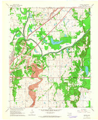
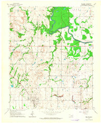 1963 Red Bird1964 Print · USGSWagoner County was a busy intersection of rail, river, and industry in the early sixties. Researchers can trace the legacy of local settlements like Red Bird and Porter, or locate specific landmarks like Lincoln Cem and the bends of the Verdigris River.4 unique versions available
 - 1963 Map of Neodesha, 1964 Print
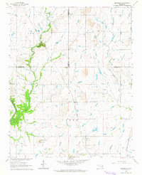 1963 Neodesha1964 Print · USGSWagoner County and its neighbors are captured in the early sixties, showing the rural landscape just as mid-century infrastructure was maturing. Genealogists can locate Lone Star Ch, Willow Cem, and the tracks of the Missouri Pacific railroad.2 unique versions available
 - 1963 Map of Coweta, 1964 Print
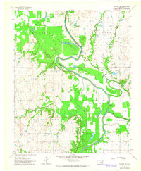
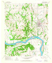 1963 Coweta1964 Print · USGSWagoner County as the oil and gas industry matured in the early sixties, centered on the Arkansas River. Trace family histories at Tiger Cem and Odd Fellow Cem or the rails of the Missouri-Kansas-Texas line.3 unique versions available
 - 1963 Map of Oneta, 1964 Print
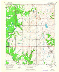
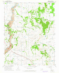 1963 Oneta1964 Print · USGSWagoner County during the early sixties shows a landscape of rail-fed settlements and active extraction. Researchers can locate family landmarks like Springtown Church and Bailey Cemetery alongside the Strip Mines and the Missouri-Kansas-Texas railroad.3 unique versions available
 - 1963 Map of Catoosa, 1964 Print
 1963 Catoosa1964 Print · USGSThe Verdigris River valley in the early sixties shows a landscape of growing infrastructure and heavy industry. Genealogists and researchers can trace rural life through the Keeton Sch, Timber Ridge Cem, and the massive Strip Mine south of Catoosa.4 unique versions available
 - 1963 Map of Catoosa SE, 1964 Print
 1963 Catoosa SE1964 Print · USGSThe Verdigris River valley in the early sixties reveals a landscape of oxbow lakes and bottomland agriculture. Genealogists and historians can trace the rural community through landmarks like Childers Cem, Thomas Ch, and the small settlement of Adams.4 unique versions available
 - 1963 Map of Inola, 1964 Print
 1963 Inola1964 Print · USGSNortheastern Oklahoma’s agricultural and industrial landscape is captured here in the early sixties, as the Verdigris River valley transitions toward Rogers and Wagoner counties. Genealogists and historians can locate rural landmarks like Sweeten Cemetery, Gregory School, and the Missouri Pacific rail corridor.3 unique versions available
 - 1965 Map of Fort Smith
 1965 Fort Smith1965 Print · USGSEastern Oklahoma and Western Arkansas are captured here during a period of massive post-war change as new reservoirs reshaped the river valleys. Genealogists and historians can trace the rail networks of the Midland Valley RR and find established communities like Stilwell, Sallisaw, and Stigler.
 - 1967 Map of Fort Smith
 1967 Fort Smith1967 Print · USGSThe Arkansas River valley and the foothills of the Ozarks are captured here during a period of significant military and industrial activity. Researchers can trace the sprawling bounds of Camp Chaffee and Camp Gruber or locate vanished rail stops along the Midland Valley RR.
End of results
Showing maps 1-10 of 10
Top cities of Wagoner County
- Coweta historical maps
- Wagoner historical maps
- Okay historical maps
- Porter historical maps
- Tullahassee historical maps
Frequently asked questions
- What are the different types of historical maps available for Wagoner County?
- What is the oldest map of Wagoner County?
- Where can I purchase historical maps of Wagoner County for my home or office?
- Where can I download high-res historical maps of Wagoner County?
- Are there historical topographic maps available for Wagoner County?
- Is there historical aerial imagery available for Wagoner County?
- Where are historical maps of Wagoner County sourced from?