1950s Maps of Washington County, Oklahoma
Explore 6 historic maps of Washington County from the 1950s. These maps offer a rare glimpse into what life looked like during the 1950s — showing old roads, neighborhoods, homes, and landmarks that have changed or disappeared over time.
Whether you're researching your family's past, planning a metal detecting trip, or studying how Washington County's landscape evolved across the 1950s, these high-resolution maps are a powerful tool for exploring the history of this region.
- Focus on a specific era: All maps on this page are from the 1950s, giving you a focused view of this time period.
- See what’s changed: Compare century-old streets, trails, and buildings to today's modern landscape using overlays and satellite layers.
- Research with precision: Use these maps for genealogy, historical research, land use analysis, or educational projects.
- View, download, or print: Maps are fully viewable online in high resolution, and can be downloaded or printed for your own records.
Start exploring Washington County's history through authentic maps from the 1950s. This is your window into the past.
Washington County, OK maps
(6)- 1954 Map of Tulsa
 1954 Tulsa1954 Print · USGSNortheast Oklahoma and the Ozark border are shown here during a period of massive industrial and infrastructure growth. Researchers can trace the legacy of the Tri-State Mining District and the development of major reservoirs like Grand Lake O' The Cherokees.2 unique versions available
 - 1955 Map of Enid, 1966 Print
 1955 Enid1966 Print · USGSNorth-central Oklahoma's transition from open plains to the blackjack hills of the Osage Indian Reservation is captured in the mid-1950s. Researchers can trace the development of the Naval Reserve Oil Field, the grounds of Vance AFB, and the early footprints of Tulsa and Stillwater.4 unique versions available
 - 1958 Map of Enid
 1958 Enid1958 Print · USGSNorthern Oklahoma is mapped here in the late fifties, showcasing a dense network of petroleum production and historic tribal lands. Researchers can trace the legacy of the Osage Indian Reservation, early energy hubs like the Cushing Oil Field, and the Chilocco Indian Agricultural School.2 unique versions available
 - 1958 Map of Tulsa, 1968 Print
 1958 Tulsa1968 Print · USGSNortheast Oklahoma and the Ozark borderlands are captured here during a massive era of reservoir construction and highway expansion. Researchers can trace the mid-century footprints of Tulsa, the sprawling Lake O' the Cherokees, and historical sites like Pea Ridge National Military Park.3 unique versions available
 - 1959 Map of Collinsville NE, 1961 Print
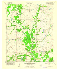 1959 Collinsville NE1961 Print · USGSNortheastern Oklahoma at the end of the fifties is a landscape of river bends and industrial growth. Researchers can trace the Caney River floodplain or locate rural landmarks like Zion Hill Ch and the strip mine operations.3 unique versions available
 - 1959 Map of Vera, 1961 Print
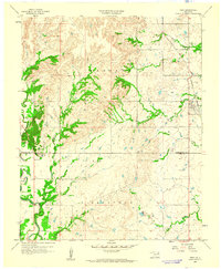 1959 Vera1961 Print · USGSThe northern Oklahoma landscape at the end of the fifties reveals a rural frontier defined by the rail line through Vera. Genealogists and historians can trace family-named landmarks like Hillside Ch and early petroleum sites including numerous Oil Wells near Bird Creek.2 unique versions available
End of results
Showing maps 1-6 of 6
Top cities of Washington County
- Bartlesville historical maps
- Dewey historical maps
- Copan historical maps
- Ramona historical maps
- Ochelata historical maps
- Vera historical maps
Frequently asked questions
- What are the different types of historical maps available for Washington County?
- What is the oldest map of Washington County?
- Where can I purchase historical maps of Washington County for my home or office?
- Where can I download high-res historical maps of Washington County?
- Are there historical topographic maps available for Washington County?
- Is there historical aerial imagery available for Washington County?
- Where are historical maps of Washington County sourced from?