1960s Maps of Woodward, Oklahoma
Explore 2 historic maps of Woodward from the 1960s. These maps offer a rare glimpse into what life looked like during the 1960s — showing old roads, neighborhoods, homes, and landmarks that have changed or disappeared over time.
Whether you're researching your family's past, planning a metal detecting trip, or studying how Woodward's landscape evolved across the 1960s, these high-resolution maps are a powerful tool for exploring the history of this region.
- Focus on a specific era: All maps on this page are from the 1960s, giving you a focused view of this time period.
- See what’s changed: Compare century-old streets, trails, and buildings to today's modern landscape using overlays and satellite layers.
- Research with precision: Use these maps for genealogy, historical research, land use analysis, or educational projects.
- View, download, or print: Maps are fully viewable online in high resolution, and can be downloaded or printed for your own records.
Start exploring Woodward's history through authentic maps from the 1960s. This is your window into the past.
Woodward, OK maps
(2)- 1969 Map of Woodward, 1971 Print
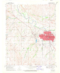 1969 Woodward1971 Print · USGSWoodward and the surrounding plains are captured in the late sixties as the city thrived as a rail and energy hub. Researchers can trace the intersection of the Atchison Topeka and Santa Fe railroad with local landmarks like Elmwood Cemetery and the Drive-in Theater.2 unique versions available
 - 1969 Map of Woodward NE, 1971 Print
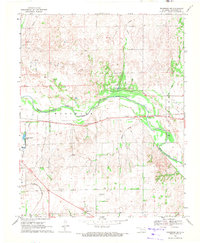 1969 Woodward NE1971 Print · USGSThe Oklahoma plains north of Woodward are captured here during a period of industrial and recreational development in the late sixties. Researchers can trace the paths of the Atchison Topeka and Santa Fe rail line and identify local landmarks like Alston and Crystal Beach Lake.
End of results
Showing maps 1-2 of 2
Top cities near Woodward
Top neighborhoods of Woodward
Frequently asked questions
- What are the different types of historical maps available for Woodward?
- What is the oldest map of Woodward?
- Where can I purchase historical maps of Woodward for my home or office?
- Where can I download high-res historical maps of Woodward?
- Are there historical topographic maps available for Woodward?
- Is there historical aerial imagery available for Woodward?
- Where are historical maps of Woodward sourced from?