
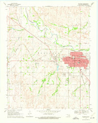
1969 Map of Woodward
USGS Topo · Published 1971About this map
The North Canadian River meanders across this northwestern Oklahoma landscape, anchoring the regional geography where Sand Creek and Roundup Creek converge. The city of Woodward serves as the dominant hub, marked by a dense grid of civic and educational institutions including the Courthouse, High Sch, and numerous neighborhood schools like Westwood Sch and Highland Park Sch. The local economy of the late 1960s is evidenced by widespread Gas Wells and Caliche Pits, while the Field Station Lake and the Fairground suggest the community's recreational spaces.
Find a feature on this map
31 named features on this map. Tap any name to fly to it.
Don’t see what you’re looking for? This feature index may not catch every label — zoom into the map to look around manually.
Map Details
Editions of this 1969 Woodward Map
2 editions found
Other maps of this area

1955 · Woodward
USGS Topo · 1:250,000

1958 · Woodward
USGS Topo · 1:250,000

1969 · Fargo
USGS Topo · 1:24,000

1969 · Woodward SW
USGS Topo · 1:24,000

1969 · Sharon
USGS Topo · 1:24,000

1969 · Fargo SE
USGS Topo · 1:24,000

1969 · Woodward NE
USGS Topo · 1:24,000

1970 · Sleeping Bear Creek SW
USGS Topo · 1:24,000

1970 · Sleeping Bear Creek SE
USGS Topo · 1:24,000

1971 · Fort Supply
USGS Topo · 1:24,000