1940s Maps of Seaside, Oregon
Explore 4 historic maps of Seaside from the 1940s. These maps offer a rare glimpse into what life looked like during the 1940s — showing old roads, neighborhoods, homes, and landmarks that have changed or disappeared over time.
Whether you're researching your family's past, planning a metal detecting trip, or studying how Seaside's landscape evolved across the 1940s, these high-resolution maps are a powerful tool for exploring the history of this region.
- Focus on a specific era: All maps on this page are from the 1940s, giving you a focused view of this time period.
- See what’s changed: Compare century-old streets, trails, and buildings to today's modern landscape using overlays and satellite layers.
- Research with precision: Use these maps for genealogy, historical research, land use analysis, or educational projects.
- View, download, or print: Maps are fully viewable online in high resolution, and can be downloaded or printed for your own records.
Start exploring Seaside's history through authentic maps from the 1940s. This is your window into the past.
Seaside, OR maps
(4)- 1940 Map of Cape Falcon
 1940 Cape Falcon1940 Print · USGSCoastal Clatsop County is captured just before the war, showing the development of Seaside and Cannon Beach along the Pacific. Researchers can trace early logging operations at the Markham Callow Logging Camp or locate the Ferndale Sch and Henderson Ranch.
 - 1948 Map of Vancouver, 1957 Print
 1948 Vancouver1957 Print · USGSPost-war growth transforms the river valleys of the Pacific Northwest as the timber and rail economy thrives. Trace family roots in Tillamook or Oregon City, and locate vanished landmarks like the spit at Bayocean or the Skamania Mine.
 - 1949 Map of Tillamook Head, 1955 Print
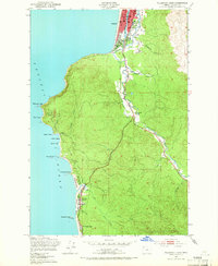 1949 Tillamook Head1955 Print · USGSThe Oregon coast at the end of the 1940s reveals a landscape of growing seaside resorts and deep timbered headlands. You can trace early transit corridors like the Old Railroad Grade or locate local landmarks including Central Sch and the monolith at Haystack Rock.3 unique versions available
 - 1949 Map of Gearhart, 1955 Print
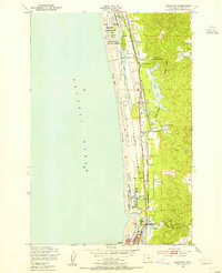 1949 Gearhart1955 Print · USGSThe Clatsop County coastline in the late 1940s reveals a landscape of military training grounds and quiet seaside resort towns. Trace the early footprints of Gearhart and Seaside alongside the Spokane Portland and Seattle Railway and the Clatsop Plains Sch.5 unique versions available
End of results
Showing maps 1-4 of 4
Top cities near Seaside
- Astoria historical maps
- Warrenton historical maps
- Cannon Beach historical maps
- Gearhart historical maps
Frequently asked questions
- What are the different types of historical maps available for Seaside?
- What is the oldest map of Seaside?
- Where can I purchase historical maps of Seaside for my home or office?
- Where can I download high-res historical maps of Seaside?
- Are there historical topographic maps available for Seaside?
- Is there historical aerial imagery available for Seaside?
- Where are historical maps of Seaside sourced from?