Old Maps of Keasey, Oregon for Metal Detecting
Plan your next treasure hunt with 15 historic maps of Keasey. Find old homesites, ghost towns, trails, and gathering spots that may be lost to time — perfect for identifying promising metal detecting locations.
- Locate forgotten sites: Uncover places like long-lost settlements, abandoned rail lines, or gathering spots.
- Plan better hunts: Use map overlays combined with LiDAR or satellite views to narrow in on historically rich areas.
- Made for detectorists: Thousands of hobbyists use these maps to discover relics, coins, and hidden history.
Use these historic maps to boost your research and find new opportunities beneath the surface of Keasey.
Keasey, OR maps
(15)- 1941 Map of Keasey
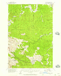
 1941 Keasey1941 Print · USGSThe timber and rail economy of northwest Oregon is captured here just before the war. Trace the path of the Oregon American Lumber Co railroad and locate family landmarks like A W Nelsons Farm and the Winema Sch.
 - 1943 Map of Keasey
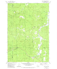
 1943 Keasey1943 Print · USGSThe timber country of the northern Oregon Coast Range comes alive in the early 1940s as loggers worked the Nehalem River basin. Researchers can trace the industrial footprint of the Oregon American Lumber Company and find small outposts like Birkenfeld, Keasey, and Neverstill.
 - 1948 Map of Vancouver, 1957 Print
 1948 Vancouver1957 Print · USGSPost-war growth transforms the river valleys of the Pacific Northwest as the timber and rail economy thrives. Trace family roots in Tillamook or Oregon City, and locate vanished landmarks like the spit at Bayocean or the Skamania Mine.
 - 1950 Map of Vancouver
 1950 Vancouver1950 Print · USGSCoastal Oregon and the lower Columbia River valley are captured in detail just after the war. Researchers can trace historic rail routes like the Southern Pacific or locate early settlements such as Vernonia, Gaston, and the Grand Ronde Indian Reservation.
 - 1950 Map of Vancouver, 1951 Print
 1950 Vancouver1951 Print · USGSThe Pacific Northwest urban corridor meets the rugged coast in the years following the war, showing the expansion of Portland and Vancouver. Genealogists and historians can trace the reach of the Southern Pacific RR and locate coastal communities like Tillamook, Seaside, and Tolovana Park.
 - 1955 Map of Birkenfeld, 1957 Print
 1955 Birkenfeld1957 Print · USGSCoastal Oregon timber country comes alive in the mid-fifties, showing the intersection of the logging industry and small rural outposts. Researchers can trace the Old Railroad Grade and locate vanished local landmarks like the Vesper Sch (Aban'd) and Camp McGregor.3 unique versions available
 - 1958 Map of Vancouver, 1968 Print
 1958 Vancouver1968 Print · USGSThe Lower Columbia and Willamette valleys thrive in the late sixties as major rail and river hubs. Genealogists and historians can trace the development of Portland, identify the grounds of Camp Withycombe, and locate coastal landmarks from Tillamook Head to Garibaldi.3 unique versions available
 - 1964 Map of Vancouver
 1964 Vancouver1964 Print · USGSThe Pacific Northwest interior and coast are shown here in the 1960s, from the Portland metropolitan hub to the rugged Pacific shoreline. Researchers can trace the legacy of the Grand Ronde Indian Reservation, the early layout of McMinnville, and the maritime approaches near Tillamook Head.
 - 1979 Map of Clear Creek, 1980 Print
 1979 Clear Creek1980 Print · USGSThe northern Coast Range comes alive in the late 1970s where four counties converge amidst the Clatsop State Forest. Researchers can trace old logging grades and family-named routes while locating historic sites like Keasey and the riverfront Cem.
 - 1979 Map of Nehalem River, 1980 Print
 1979 Nehalem River1980 Print · USGSThe northern Oregon coast and its timber-rich interior are captured here in the late seventies, showing the vital connection between sea and forest. Researchers can trace the rail lines of the Southern Pacific and Burlington Northern through historic logging hubs like Vernonia, Timber, and Nehalem.3 unique versions available
 - 2011 Map of Clear Creek, 2011 Print
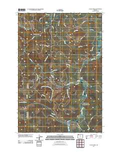 2011 Clear Creek2011 Print · USGSCovers Keasey, including Clear Creek, Washington County, and other nearby areas
 - 2014 Map of Clear Creek, 2014 Print
 2014 Clear Creek2014 Print · USGSCovers Keasey, including Clear Creek, Washington County, and other nearby areas
 - 2017 Map of Clear Creek, 2017 Print
 2017 Clear Creek2017 Print · USGSCovers Keasey, including Clear Creek, Washington County, and other nearby areas
 - 2020 Map of Clear Creek, 2020 Print
 2020 Clear Creek2020 Print · USGSCovers Keasey, including Clear Creek, Washington County, and other nearby areas
 - 2023 Map of Clear Creek, 2023 Print
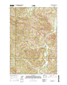
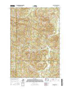
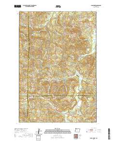
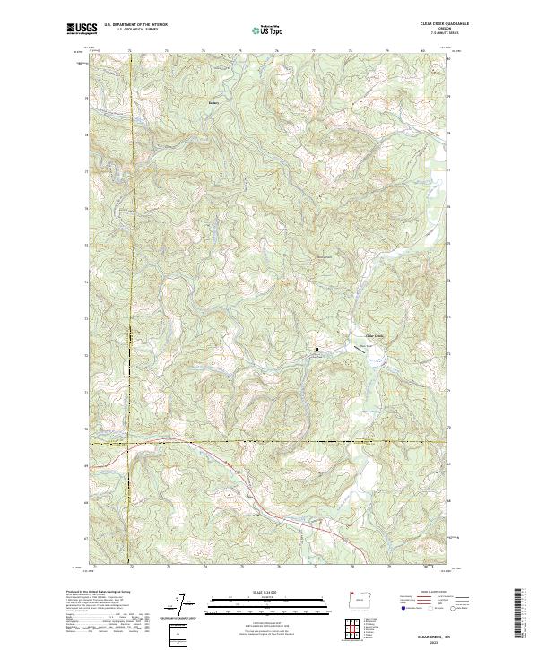 2023 Clear Creek2023 Print · USGSThe Nehalem River headwaters and surrounding timberlands are documented here in the early twenty-first century as they span four Oregon counties. Researchers can trace the layout of local landmarks like Keasey, Bero Field, and the North Cam of Clear Creek.
End of results
Showing maps 1-15 of 15
Top cities near Keasey
Frequently asked questions
- What are the different types of historical maps available for Keasey?
- What is the oldest map of Keasey?
- Where can I purchase historical maps of Keasey for my home or office?
- Where can I download high-res historical maps of Keasey?
- Are there historical topographic maps available for Keasey?
- Is there historical aerial imagery available for Keasey?
- Where are historical maps of Keasey sourced from?