1940s Maps of Pittsburg, Oregon
Explore 3 historic maps of Pittsburg from the 1940s. These maps offer a rare glimpse into what life looked like during the 1940s — showing old roads, neighborhoods, homes, and landmarks that have changed or disappeared over time.
Whether you're researching your family's past, planning a metal detecting trip, or studying how Pittsburg's landscape evolved across the 1940s, these high-resolution maps are a powerful tool for exploring the history of this region.
- Focus on a specific era: All maps on this page are from the 1940s, giving you a focused view of this time period.
- See what’s changed: Compare century-old streets, trails, and buildings to today's modern landscape using overlays and satellite layers.
- Research with precision: Use these maps for genealogy, historical research, land use analysis, or educational projects.
- View, download, or print: Maps are fully viewable online in high resolution, and can be downloaded or printed for your own records.
Start exploring Pittsburg's history through authentic maps from the 1940s. This is your window into the past.
Pittsburg, OR maps
(3)- 1940 Map of Vernonia, 1941 Print
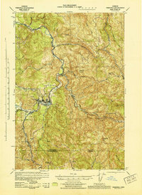
 1940 Vernonia1941 Print · USGSNorthwestern Oregon’s timber country comes into focus in this 1940 survey, showing the river-valley settlements just before the Second World War. Researchers can trace early rural life through landmarks like Pleasant Hill School, the town of Vernonia, and the Catherwood Lookout.
 - 1943 Map of Vernonia
 1943 Vernonia1943 Print · USGSUpper Nehalem Valley life in the early 1940s is defined here by the logging railways and riverside hamlets of Columbia County. You can trace the United Railways line into Vernonia or locate vanished rural schoolhouses like Beaver Creek Sch and Natal Sch.
 - 1948 Map of Vancouver, 1957 Print
 1948 Vancouver1957 Print · USGSPost-war growth transforms the river valleys of the Pacific Northwest as the timber and rail economy thrives. Trace family roots in Tillamook or Oregon City, and locate vanished landmarks like the spit at Bayocean or the Skamania Mine.
End of results
Showing maps 1-3 of 3
Top cities near Pittsburg
- Longview historical maps
- Vernonia historical maps
- Rainier historical maps
- Clatskanie historical maps
- Timber historical maps
Frequently asked questions
- What are the different types of historical maps available for Pittsburg?
- What is the oldest map of Pittsburg?
- Where can I purchase historical maps of Pittsburg for my home or office?
- Where can I download high-res historical maps of Pittsburg?
- Are there historical topographic maps available for Pittsburg?
- Is there historical aerial imagery available for Pittsburg?
- Where are historical maps of Pittsburg sourced from?