Old Maps of Pittsburg, Oregon for Genealogy
Trace your family roots with 13 historic maps of Pittsburg. These high-res maps reveal old neighborhoods, homesites, landmarks, and streets — helping you uncover where your ancestors lived and how the area evolved over time.
- Explore historic neighborhoods: Identify where your relatives may have lived in the 1800s or 1900s.
- Compare maps over time: Trace the changes in streets, buildings, and landmarks for multi-generational research.
- Perfect for genealogy & ancestry research: Used by family historians and researchers to map out lineage and migration.
These maps are an incredible resource for exploring your personal connection to Pittsburg's past.
Pittsburg, OR maps
(13)- 1940 Map of Vernonia, 1941 Print
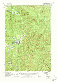
 1940 Vernonia1941 Print · USGSNorthwestern Oregon’s timber country comes into focus in this 1940 survey, showing the river-valley settlements just before the Second World War. Researchers can trace early rural life through landmarks like Pleasant Hill School, the town of Vernonia, and the Catherwood Lookout.
 - 1943 Map of Vernonia
 1943 Vernonia1943 Print · USGSUpper Nehalem Valley life in the early 1940s is defined here by the logging railways and riverside hamlets of Columbia County. You can trace the United Railways line into Vernonia or locate vanished rural schoolhouses like Beaver Creek Sch and Natal Sch.
 - 1948 Map of Vancouver, 1957 Print
 1948 Vancouver1957 Print · USGSPost-war growth transforms the river valleys of the Pacific Northwest as the timber and rail economy thrives. Trace family roots in Tillamook or Oregon City, and locate vanished landmarks like the spit at Bayocean or the Skamania Mine.
 - 1950 Map of Vancouver
 1950 Vancouver1950 Print · USGSCoastal Oregon and the lower Columbia River valley are captured in detail just after the war. Researchers can trace historic rail routes like the Southern Pacific or locate early settlements such as Vernonia, Gaston, and the Grand Ronde Indian Reservation.
 - 1950 Map of Vancouver, 1951 Print
 1950 Vancouver1951 Print · USGSThe Pacific Northwest urban corridor meets the rugged coast in the years following the war, showing the expansion of Portland and Vancouver. Genealogists and historians can trace the reach of the Southern Pacific RR and locate coastal communities like Tillamook, Seaside, and Tolovana Park.
 - 1955 Map of Vernonia, 1957 Print
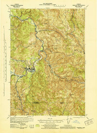
 1955 Vernonia1957 Print · USGSIn the mid-1950s, the logging and rail infrastructure of Columbia County centered on the riverside hub of Vernonia. Researchers can trace the decline of rural districts through Natal School or locate family roots at the Pioneer Cem and Pittsburg.3 unique versions available
 - 1958 Map of Vancouver, 1968 Print
 1958 Vancouver1968 Print · USGSThe Lower Columbia and Willamette valleys thrive in the late sixties as major rail and river hubs. Genealogists and historians can trace the development of Portland, identify the grounds of Camp Withycombe, and locate coastal landmarks from Tillamook Head to Garibaldi.3 unique versions available
 - 1964 Map of Vancouver
 1964 Vancouver1964 Print · USGSThe Pacific Northwest interior and coast are shown here in the 1960s, from the Portland metropolitan hub to the rugged Pacific shoreline. Researchers can trace the legacy of the Grand Ronde Indian Reservation, the early layout of McMinnville, and the maritime approaches near Tillamook Head.
 - 1979 Map of Pittsburg, 1980 Print
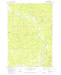 1979 Pittsburg1980 Print · USGSColumbia County’s timber country is documented here in the late seventies, centered on the winding Nehalem River valley. Genealogists and local historians can trace the small settlements of Natal and Pittsburg or find isolated markers like the lone Grave and Big Eddy Park.
 - 1979 Map of Nehalem River, 1980 Print
 1979 Nehalem River1980 Print · USGSThe northern Oregon coast and its timber-rich interior are captured here in the late seventies, showing the vital connection between sea and forest. Researchers can trace the rail lines of the Southern Pacific and Burlington Northern through historic logging hubs like Vernonia, Timber, and Nehalem.3 unique versions available
 - 2011 Map of Pittsburg, 2011 Print
 2011 Pittsburg2011 Print · USGSCovers Pittsburg, including Columbia County, United States, and other nearby areas
 - 2020 Map of Pittsburg, 2020 Print
 2020 Pittsburg2020 Print · USGSCovers Pittsburg, including Columbia County, United States, and other nearby areas
 - 2023 Map of Pittsburg, 2023 Print
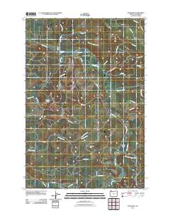
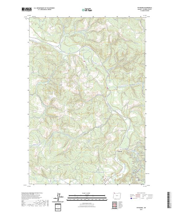 2023 Pittsburg2023 Print · USGSColumbia County's timberlands and river valleys are captured here in the early twenty-first century. Researchers can trace the winding Nehalem River, locate rural junctions like Pittsburg, and explore remote landmarks such as Lindsay Lake and Enterprise Point.
End of results
Showing maps 1-13 of 13
Top cities near Pittsburg
- Longview historical maps
- Vernonia historical maps
- Rainier historical maps
- Clatskanie historical maps
- Timber historical maps
Frequently asked questions
- What are the different types of historical maps available for Pittsburg?
- What is the oldest map of Pittsburg?
- Where can I purchase historical maps of Pittsburg for my home or office?
- Where can I download high-res historical maps of Pittsburg?
- Are there historical topographic maps available for Pittsburg?
- Is there historical aerial imagery available for Pittsburg?
- Where are historical maps of Pittsburg sourced from?