1980s Maps of Port Orford, Oregon
Explore 3 historic maps of Port Orford from the 1980s. These maps offer a rare glimpse into what life looked like during the 1980s — showing old roads, neighborhoods, homes, and landmarks that have changed or disappeared over time.
Whether you're researching your family's past, planning a metal detecting trip, or studying how Port Orford's landscape evolved across the 1980s, these high-resolution maps are a powerful tool for exploring the history of this region.
- Focus on a specific era: All maps on this page are from the 1980s, giving you a focused view of this time period.
- See what’s changed: Compare century-old streets, trails, and buildings to today's modern landscape using overlays and satellite layers.
- Research with precision: Use these maps for genealogy, historical research, land use analysis, or educational projects.
- View, download, or print: Maps are fully viewable online in high resolution, and can be downloaded or printed for your own records.
Start exploring Port Orford's history through authentic maps from the 1980s. This is your window into the past.
Port Orford, OR maps
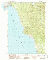
(3)- 1986 Map of Cape Blanco
 1986 Cape Blanco1986 Print · USGSThe Oregon coast at the mid-eighties reveals a landscape of lighthouse navigation, cranberry farming, and river mouths. Researchers can trace the grounds of the Lighthouse at Cape Blanco, locate the Cem near the cliffs, and map the early layout of Port Orford by Garrison Lake.
 - 1986 Map of Port Orford
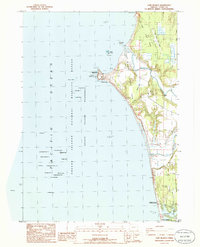
 1986 Port Orford1986 Print · USGSCoastal Oregon life in the mid-eighties centered on the harbor at Port Orford and the dramatic shoreline of the Pacific Ocean. Trace local landmarks from the US Coast Guard Station to the Elk River State Fish Hatchery and the peaks of Humbug Mountain.
 - 1986 Map of Sixes
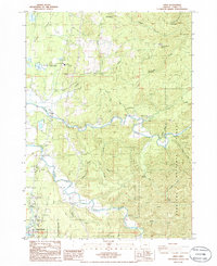 1986 Sixes1986 Print · USGSCoastal Curry County is documented here in the mid-eighties, where the Sixes River meets the Pacific near rural timberlands. Researchers can locate the Pacific High Sch, the sprawling Cranberry Bogs, and the Port Orford Cedar Forest State Wayside.
End of results
Showing maps 1-3 of 3
Frequently asked questions
- What are the different types of historical maps available for Port Orford?
- What is the oldest map of Port Orford?
- Where can I purchase historical maps of Port Orford for my home or office?
- Where can I download high-res historical maps of Port Orford?
- Are there historical topographic maps available for Port Orford?
- Is there historical aerial imagery available for Port Orford?
- Where are historical maps of Port Orford sourced from?