1950s Maps of Port Orford, Oregon
Explore 5 historic maps of Port Orford from the 1950s. These maps offer a rare glimpse into what life looked like during the 1950s — showing old roads, neighborhoods, homes, and landmarks that have changed or disappeared over time.
Whether you're researching your family's past, planning a metal detecting trip, or studying how Port Orford's landscape evolved across the 1950s, these high-resolution maps are a powerful tool for exploring the history of this region.
- Focus on a specific era: All maps on this page are from the 1950s, giving you a focused view of this time period.
- See what’s changed: Compare century-old streets, trails, and buildings to today's modern landscape using overlays and satellite layers.
- Research with precision: Use these maps for genealogy, historical research, land use analysis, or educational projects.
- View, download, or print: Maps are fully viewable online in high resolution, and can be downloaded or printed for your own records.
Start exploring Port Orford's history through authentic maps from the 1950s. This is your window into the past.
Port Orford, OR maps
(5)- 1954 Map of Coos Bay
 1954 Coos Bay1954 Print · USGSCoastal Oregon at mid-century shows a landscape of timber and tides, from the river ports to the edge of the Pacific. Researchers can trace family roots through coastal schools like Beachview School or follow the Southern Pacific RR through Reedsport and Coos Bay.
 - 1954 Map of Port Orford, 1956 Print
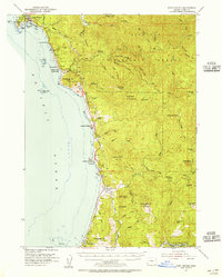 1954 Port Orford1956 Print · USGSThe Oregon coast at the mid-century mark reveals a landscape of isolated shoreline settlements and dense national forest. Researchers can trace family history through the Cem at Ophir or locate old coastal landmarks like Frankport and the Coast Guard Sta at Port Orford.3 unique versions available
 - 1954 Map of Cape Blanco, 1956 Print
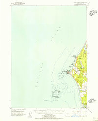 1954 Cape Blanco1956 Print · USGSCoastal Curry County at the height of the 1950s shows a landscape defined by its maritime hazards and river-mouth agriculture. Researchers can trace the layout of the Cranberry Bogs, the grounds of Cape Blanco State Park, and dozens of named offshore rocks like Best Rock and Seal Rock.3 unique versions available
 - 1954 Map of Langlois, 1956 Print
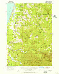 1954 Langlois1956 Print · USGSCoastal Curry County in the mid-fifties is a landscape of cranberry agriculture and rugged timberlands. Researchers can trace the early highway settlements of Denmark and Langlois or locate coastal landmarks like Floras Lake and the Cranberry Bogs.3 unique versions available
 - 1958 Map of Coos Bay, 1974 Print
 1958 Coos Bay1974 Print · USGSThe Southern Oregon coastline at mid-century reveals a bustling maritime and timber economy centered on Coos Bay and North Bend. Researchers can trace the legacy of coastal settlements from Bandon to Brookings, including rail lines of the Southern Pacific RR and the rugged reaches of the Siuslaw National Forest.
End of results
Showing maps 1-5 of 5
Frequently asked questions
- What are the different types of historical maps available for Port Orford?
- What is the oldest map of Port Orford?
- Where can I purchase historical maps of Port Orford for my home or office?
- Where can I download high-res historical maps of Port Orford?
- Are there historical topographic maps available for Port Orford?
- Is there historical aerial imagery available for Port Orford?
- Where are historical maps of Port Orford sourced from?