1990s Maps of Port Orford, Oregon
Explore 4 historic maps of Port Orford from the 1990s. These maps offer a rare glimpse into what life looked like during the 1990s — showing old roads, neighborhoods, homes, and landmarks that have changed or disappeared over time.
Whether you're researching your family's past, planning a metal detecting trip, or studying how Port Orford's landscape evolved across the 1990s, these high-resolution maps are a powerful tool for exploring the history of this region.
- Focus on a specific era: All maps on this page are from the 1990s, giving you a focused view of this time period.
- See what’s changed: Compare century-old streets, trails, and buildings to today's modern landscape using overlays and satellite layers.
- Research with precision: Use these maps for genealogy, historical research, land use analysis, or educational projects.
- View, download, or print: Maps are fully viewable online in high resolution, and can be downloaded or printed for your own records.
Start exploring Port Orford's history through authentic maps from the 1990s. This is your window into the past.
Port Orford, OR maps
(4)- 1992 Map of Port Orford, 1993 Print
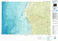 1992 Port Orford1993 Print · USGSThe southern Oregon coast and the coastal ranges of the early nineties are captured here in both topographic and bathymetric detail. Researchers can trace landforms from the reefs of Oregon Islands to inland landmarks like Bingham Mountain and Albert H Powers Memorial State Park.
 - 1996 Map of Sixes, 1999 Print
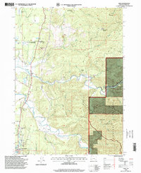 1996 Sixes1999 Print · USGSThe coastal river valleys of Curry County are shown in the late 1990s as the landscape transitions from the small town of Sixes into deep timber country. Researchers can trace the Sixes River to the Grassy Knob Wilderness and locate the Pacific High School or the Port Orford Cedar Forest State Wayside.
 - 1996 Map of Cape Blanco, 1999 Print
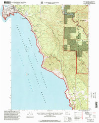
 1996 Cape Blanco1999 Print · USGSThe Oregon coast at its westernmost extremity is captured in the mid-nineties, showing the intersection of maritime heritage and cranberry agriculture. Genealogists and local historians can locate the Lighthouse at Cape Blanco, several Cranberry Bogs, and the northern reaches of Port Orford.
 - 1996 Map of Port Orford, 1999 Print
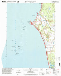
 1996 Port Orford1999 Print · USGSPort Orford and the Southern Oregon coast in the late twentieth century show a landscape shaped by maritime history and conservation. Trace local landmarks like the US Coast Guard Station, Graveyard Point, and the Elk River State Fish Hatchery.
End of results
Showing maps 1-4 of 4
Frequently asked questions
- What are the different types of historical maps available for Port Orford?
- What is the oldest map of Port Orford?
- Where can I purchase historical maps of Port Orford for my home or office?
- Where can I download high-res historical maps of Port Orford?
- Are there historical topographic maps available for Port Orford?
- Is there historical aerial imagery available for Port Orford?
- Where are historical maps of Port Orford sourced from?