Old Maps of Myrtle Creek, Oregon for Genealogy
Trace your family roots with 22 historic maps of Myrtle Creek. These high-res maps reveal old neighborhoods, homesites, landmarks, and streets — helping you uncover where your ancestors lived and how the area evolved over time.
- Explore historic neighborhoods: Identify where your relatives may have lived in the 1800s or 1900s.
- Compare maps over time: Trace the changes in streets, buildings, and landmarks for multi-generational research.
- Perfect for genealogy & ancestry research: Used by family historians and researchers to map out lineage and migration.
These maps are an incredible resource for exploring your personal connection to Myrtle Creek's past.
Myrtle Creek, OR maps
(22)- 1897 Map of Roseburg
 1897 Roseburg1897 Print · USGSDouglas County settlements flourished along the river bends and rail lines during the 1890s. Genealogists and historians can trace early homesteads and towns like Oakland, Roseburg, and Myrtle Creek, alongside landmarks such as Camas Swale.
 - 1900 Map of Roseburg
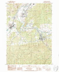
 1900 Roseburg1900 Print · USGSDouglas County at the turn of the century shows a landscape transitioning through the arrival of the Southern Pacific railroad. Genealogists and local historians can trace early river crossings like Lone Rock Ferry and explore the layouts of Oakland, Winchester, and Myrtle Creek.5 unique versions available
 - 1904 Map of Riddle
 1904 Riddle1904 Print · USGSSouthern Oregon's mining and railroad corridor is captured here at the start of the twentieth century. Genealogists can trace family footprints through early settlements like Riddles and Galesville or locate specific claims like the Placer Star Mine.5 unique versions available
 - 1954 Map of Canyonville, 1956 Print
 1954 Canyonville1956 Print · USGSSouthern Douglas County at mid-century shows a landscape shaped by timber, mining, and the vital rail corridor of the Southern Pacific. Researchers can trace the development of Riddle and Canyonville, locate the industrial site at Nickel Mine, and identify historical locations like Galesville.2 unique versions available
 - 1955 Map of Roseburg, 1957 Print
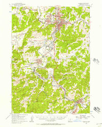 1955 Roseburg1957 Print · USGSMid-century Douglas County comes to life through this record of the river valleys south of Roseburg. Genealogists and historians can trace family locations near Melrose Cem, identify old school sites like Green School, or locate the Sawmill and Southern Pacific rail stops that drove the local timber economy.4 unique versions available
 - 1955 Map of Medford, 1964 Print
 1955 Medford1964 Print · USGSSouthern Oregon's valley towns and high peaks are captured here in the mid-1950s, showing the region before the completion of the modern interstate system. Genealogists and historians can trace the development of timber and mining outposts from Wolf Creek to Butte Falls and the early roads to Crater Lake.3 unique versions available
 - 1957 Map of Medford
 1957 Medford1957 Print · USGSSouthern Oregon during the mid-fifties is captured here as a region of growing valley cities and vast timberlands. Genealogists and historians can trace the rail-and-road corridors connecting Medford, Jacksonville, and Grants Pass to more remote locales like Wolf Creek or Butte Falls.
 - 1958 Map of Medford
 1958 Medford1958 Print · USGSSouthern Oregon's Rogue River valley thrived in the 1950s as a crossroads of rail and road. Researchers can trace the legacy of timber and tourism through Southern Pacific RR lines and landmarks like Crater Lake and Oregon Caves National Monument.
 - 1958 Map of Roseburg, 1960 Print
 1958 Roseburg1960 Print · USGSThe timber valleys and high volcanic peaks of Southern Oregon are captured here in the late fifties. Researchers can trace the Southern Pacific rail line through historic settlements like Cottage Grove, Yoncalla, and Oakridge near the Cascade Range crest.4 unique versions available
 - 1959 Map of Roseburg
 1959 Roseburg1959 Print · USGSThe Umpqua and Willamette valleys meet the high Cascades in this late-fifties study of Southern Oregon's timber and rail corridors. Genealogists and researchers can trace the Southern Pacific RR through historic towns like Roseburg, Yoncalla, and Cottage Grove.
 - 1979 Map of Roseburg
 1979 Roseburg1979 Print · USGSThe Umpqua River valley and the foothills of the Coast Range are captured here during a period of active timber and mineral production in the late seventies. Researchers can trace the paths of the Southern Pacific and the Bonanza Mine alongside small settlements like Coles Valley and Nonpareil.
 - 1986 Map of Canyonville
 1986 Canyonville1986 Print · USGSDouglas County’s river valleys and mining ridges are detailed here in the mid-1980s as the timber and mineral industry shaped the landscape. Trace local heritage at the Levens Ledge Mine, find family names like Lawson Bar, or locate old landmarks in Canyonville and Riddle.
 - 1987 Map of Myrtle Creek
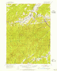
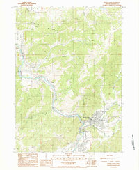 1987 Myrtle Creek1987 Print · USGSThe South Umpqua River valley in Douglas County is shown here during the late 1980s as the community expanded around its historic river-and-creek junctions. Genealogists and researchers can trace the vicinity of Myrtle Creek, find local Cemeteries, or locate industrial landmarks like the Sanitary Transfer Station and Ruckles.
 - 1989 Map of Canyonville
 1989 Canyonville1989 Print · USGSSouthern Oregon's timber and rail corridors come into focus during the late eighties as communities like Canyonville and Riddle anchor the local economy. Researchers can trace the path of the Southern Pacific Railroad and locate early settlements such as Placer, Leland, and Sunny Valley.2 unique versions available
 - 2011 Map of Canyonville, 2011 Print
 2011 Canyonville2011 Print · USGSCovers Myrtle Creek, including Canyonville, Riddle, and other nearby areas
 - 2014 Map of Myrtle Creek, 2014 Print
 2014 Myrtle Creek2014 Print · USGSCovers Myrtle Creek, including Round Prairie, Weaver, and other nearby areas
 - 2014 Map of Canyonville, 2014 Print
 2014 Canyonville2014 Print · USGSCovers Myrtle Creek, including Canyonville, Riddle, and other nearby areas
 - 2017 Map of Myrtle Creek, 2017 Print
 2017 Myrtle Creek2017 Print · USGSCovers Myrtle Creek, including Round Prairie, Weaver, and other nearby areas
 - 2017 Map of Canyonville, 2017 Print
 2017 Canyonville2017 Print · USGSCovers Myrtle Creek, including Canyonville, Riddle, and other nearby areas
 - 2020 Map of Myrtle Creek, 2020 Print
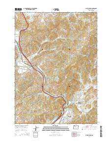
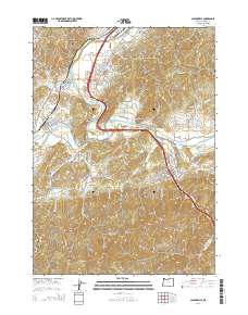
 2020 Myrtle Creek2020 Print · USGSCovers Myrtle Creek, including Round Prairie, Weaver, and other nearby areas
 - 2023 Map of Myrtle Creek, 2023 Print
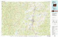
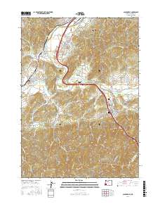
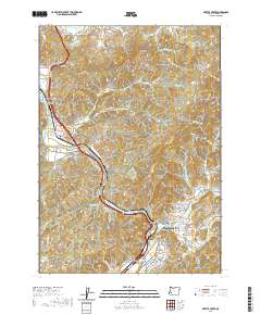
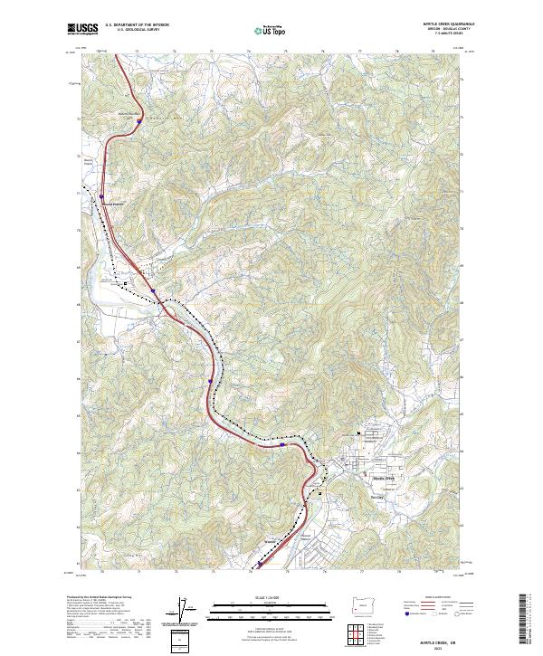 2023 Myrtle Creek2023 Print · USGSDouglas County’s river valleys and ridgelines are documented here in the early 2020s, showing the modern footprint of Myrtle Creek and Tri-City. Local historians can trace family sites near Burnett Cem or follow the course of the South Umpqua River past Missouri Bottom.
 - 2024 Map of Canyonville, 2024 Print
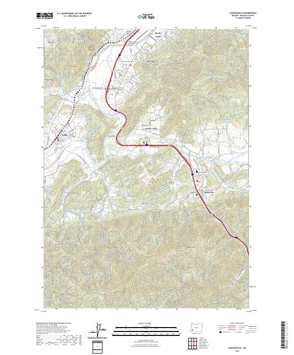 2024 Canyonville2024 Print · USGSSouthern Douglas County settlements along the South Umpqua River are shown here in the 2020s, highlighting the valley's timber and transport history. Genealogists can locate several historic burial sites, including Rosehill Cem and Pioneer Cem, alongside landmarks like the Myrtle Creek Municipal Airport.
End of results
Showing maps 1-22 of 22
Top cities near Myrtle Creek
Frequently asked questions
- What are the different types of historical maps available for Myrtle Creek?
- What is the oldest map of Myrtle Creek?
- Where can I purchase historical maps of Myrtle Creek for my home or office?
- Where can I download high-res historical maps of Myrtle Creek?
- Are there historical topographic maps available for Myrtle Creek?
- Is there historical aerial imagery available for Myrtle Creek?
- Where are historical maps of Myrtle Creek sourced from?