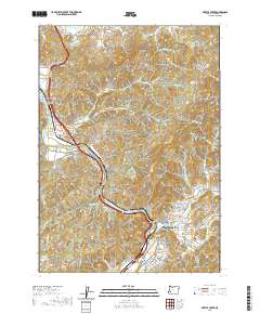
2020 Map of Myrtle Creek
USGS Topo · Published 2020About this map
The South Umpqua River carves a deep path through the Douglas County hills, defining the settlement patterns and transport corridors for Myrtle Creek and its neighboring communities. This 2020 survey documents the town's position at the confluence of Myrtle Cr and the river, showing a landscape where modern development and local history remain intertwined. Genealogists can find several established burial grounds, including the Myrtle Creek Pioneer Cem and the IOOF Cem, while the Neal Lane Bridge provides a vital link over the water.
Find a feature on this map
82 named features on this map. Tap any name to fly to it.
Don’t see what you’re looking for? This feature index may not catch every label — zoom into the map to look around manually.
Map Details
Editions of this 2020 Myrtle Creek Map
This is the sole edition of this map. No revisions or reprints were ever made.
Other maps of this area

1897 · Roseburg
USGS Topo · 1:125,000

1900 · Roseburg
USGS Topo · 1:125,000

1904 · Riddle
USGS Topo · 1:125,000

1954 · Dixonville
USGS Topo · 1:62,500

1954 · Days Creek
USGS Topo · 1:62,500

1954 · Canyonville
USGS Topo · 1:62,500

1955 · Roseburg
USGS Topo · 1:62,500

1955 · Medford
USGS Topo · 1:250,000

1957 · Medford
USGS Topo · 1:250,000

1958 · Medford
USGS Topo · 1:250,000