1900s (20th Century) Maps of Mayville, Oregon
Explore 6 historic maps of Mayville from the 1900s (20th Century). These maps offer a rare glimpse into what life looked like during the 1900s — showing old roads, neighborhoods, homes, and landmarks that have changed or disappeared over time.
Whether you're researching your family's past, planning a metal detecting trip, or studying how Mayville's landscape evolved across the 1900s, these high-resolution maps are a powerful tool for exploring the history of this region.
- Focus on a specific era: All maps on this page are from the 1900s, giving you a focused view of this time period.
- See what’s changed: Compare century-old streets, trails, and buildings to today's modern landscape using overlays and satellite layers.
- Research with precision: Use these maps for genealogy, historical research, land use analysis, or educational projects.
- View, download, or print: Maps are fully viewable online in high resolution, and can be downloaded or printed for your own records.
Start exploring Mayville's history through authentic maps from the 1900s. This is your window into the past.
Mayville, OR maps
(6)- 1916 Map of Condon
 1916 Condon1916 Print · USGSNorth-central Oregon at the start of the twentieth century was a land of high plateaus and deep canyons centered on the Condon wheat country. Genealogists can trace a vast network of rural schoolhouses like Linville School and Buckhorn School, alongside early rail stops at Mikkalo and Gwendolen.3 unique versions available
 - 1953 Map of The Dalles, 1965 Print
 1953 The Dalles1965 Print · USGSThe Columbia River Gorge at mid-century shows a region being transformed by massive hydroelectric dams and a growing highway network. Researchers can trace the development of The Dalles Dam, locate the Maryhill Museum, and find old rail stops in Rufus, Wishram, and Arlington.3 unique versions available
 - 1956 Map of The Dalles
 1956 The Dalles1956 Print · USGSThe Columbia River Gorge and the high Cascades are captured in the mid-1950s, showing a vital corridor of rail and road. Researchers can trace the original path of The Old Oregon Trail or locate historical landmarks like the Maryhill Museum and Mount Hood.
 - 1957 Map of The Dalles
 1957 The Dalles1957 Print · USGSThe Columbia River Gorge and the high plateaus of the mid-1950s come alive on this detailed survey of northern Oregon and southern Washington. Researchers can trace the path of the Oregon Trail and The Old Barlow Road alongside river towns like The Dalles and Wishram.
 - 1970 Map of Fossil North, 1973 Print
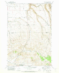 1970 Fossil North1973 Print · USGSNorth of the Wheeler County seat in the early 1970s, the plateau gives way to the deep drainages of the John Day country. Researchers can locate the Mayville Cem, trace the winding Condon Kinzua & Southern railroad, and find local landmarks like Black Butte.
 - 1981 Map of Condon, 1997 Print
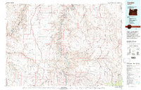 1981 Condon1997 Print · USGSNorth-central Oregon in the early eighties reveals a vast plateau landscape defined by the deep canyons of the John Day and Deschutes rivers. Researchers can trace the rural legacy of the region through small hubs like Condon, Fossil, and the Old Railroad Grade.2 unique versions available
End of results
Showing maps 1-6 of 6
Top cities near Mayville
Frequently asked questions
- What are the different types of historical maps available for Mayville?
- What is the oldest map of Mayville?
- Where can I purchase historical maps of Mayville for my home or office?
- Where can I download high-res historical maps of Mayville?
- Are there historical topographic maps available for Mayville?
- Is there historical aerial imagery available for Mayville?
- Where are historical maps of Mayville sourced from?