1990s Maps of Izee, Oregon
Explore 2 historic maps of Izee from the 1990s. These maps offer a rare glimpse into what life looked like during the 1990s — showing old roads, neighborhoods, homes, and landmarks that have changed or disappeared over time.
Whether you're researching your family's past, planning a metal detecting trip, or studying how Izee's landscape evolved across the 1990s, these high-resolution maps are a powerful tool for exploring the history of this region.
- Focus on a specific era: All maps on this page are from the 1990s, giving you a focused view of this time period.
- See what’s changed: Compare century-old streets, trails, and buildings to today's modern landscape using overlays and satellite layers.
- Research with precision: Use these maps for genealogy, historical research, land use analysis, or educational projects.
- View, download, or print: Maps are fully viewable online in high resolution, and can be downloaded or printed for your own records.
Start exploring Izee's history through authentic maps from the 1990s. This is your window into the past.
Izee, OR maps
(2)- 1990 Map of Izee
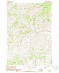 1990 Izee1990 Print · USGSGrant County ranching and timber lands are captured here in the late twentieth century, centered on the South Fork John Day River. Researchers can trace old family holdings like Kerrins Ranch and identify historical industrial locations such as the Bush Mill (Site).
 - 1998 Map of Izee, 2000 Print
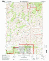 1998 Izee2000 Print · USGSHigh-elevation ranching and timber country in the late nineties is documented here, centered on the South Fork John Day River. Researchers can locate the settlement of Izee, the Bush Mill (Site), and the local Cem among the peaks.
End of results
Showing maps 1-2 of 2
Frequently asked questions
- What are the different types of historical maps available for Izee?
- What is the oldest map of Izee?
- Where can I purchase historical maps of Izee for my home or office?
- Where can I download high-res historical maps of Izee?
- Are there historical topographic maps available for Izee?
- Is there historical aerial imagery available for Izee?
- Where are historical maps of Izee sourced from?