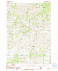
1990 Map of Izee
USGS Topo · Published 1990About this map
Izee sits at the heart of this high-desert landscape in Grant County, where the South Fork John Day River winds through a complex network of gulches and draws. The settlement patterns reflect the region's ranching heritage, with dispersed family holdings like Kerrins Ranch, Phillips Ranch, and Smith Ranch situated near vital water sources. The area is heavily marked by its timber and topographic history, evidenced by the Bush Mill (Site) in the southern portion within the Malheur National Forest. Notable landmarks such as Hole-in-the Ground and Moonshine Alley suggest a colorful local nomenclature for the terrain features surrounding Morgan Mtn and Harrison Mountain. This survey documents the intersection of public forest lands and private ranching interests at the close of the twentieth century.
Find a feature on this map
42 named features on this map. Tap any name to fly to it.
Don’t see what you’re looking for? This feature index may not catch every label — zoom into the map to look around manually.
Map Details
Editions of this 1990 Izee Map
This is the sole edition of this map. No revisions or reprints were ever made.
Other maps of this area

1932 · Dayville
USGS Topo · 1:125,000

1936 · Dayville
USGS Topo · 1:125,000

1955 · Burns
USGS Topo · 1:250,000

1955 · Canyon City
USGS Topo · 1:250,000

1958 · Burns
USGS Topo · 1:250,000

1959 · Burns
USGS Topo · 1:250,000

1959 · Canyon City
USGS Topo · 1:250,000

1959 · Sawtooth Creek
USGS Topo · 1:62,500

1961 · Delintment Lake
USGS Topo · 1:62,500

1961 · Izee
USGS Topo · 1:62,500