
1961 Map of Izee
USGS Topo · Published 1963About this map
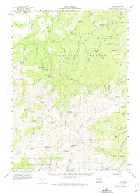
The settlement of Izee sits at the heart of this 1961 field-checked survey, positioned along the John Day River within the Malheur National Forest. The landscape is defined by the high-elevation peaks of the Blue Mountains, including prominent landmarks like Graylock Butte, Frenchy Butte, and Big Baldy. A legacy of early resource extraction is evident in the remote timber and mining operations scattered throughout the drainage basins, notably the Buck Mill (Site) and mineral prospects like the Robe Westfall Mine and Rebe Bros Mine.
Find a feature on this map
111 named features on this map. Tap any name to fly to it.
Don’t see what you’re looking for? This feature index may not catch every label — zoom into the map to look around manually.
Map Details
Editions of this 1961 Izee Map
2 editions found
Other maps of this area

1932 · Dayville
USGS Topo · 1:125,000

1936 · Dayville
USGS Topo · 1:125,000

1940 · Mount Vernon
USGS Topo · 1:62,500

1940 · Aldrich Mtn.
USGS Topo · 1:62,500

1943 · Aldrich Mtn.
USGS Topo · 1:62,500

1943 · Mount Vernon
USGS Topo · 1:62,500

1955 · Burns
USGS Topo · 1:250,000

1955 · Canyon City
USGS Topo · 1:250,000

1958 · Burns
USGS Topo · 1:250,000

1959 · Burns
USGS Topo · 1:250,000