
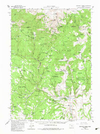
1959 Map of Sawtooth Creek
USGS Topo · Published 1960About this map
The high timber and rangeland of the Malheur National Forest dominate this late 1950s survey, illustrating a landscape managed for both timber and livestock. Significant infrastructure for forest management is visible at the Snow Mtn Lookout, the Bear Tree Guard Station, and the Blue Creek Work Center. The area is defined by a network of ranching outposts, including the Ramsey Ranch, Rickman Ranch, and Carey Ranch, which are connected by a system of rugged jeep trails and horse tracks. High-elevation landmarks like Snow Mtn and Donivan Mtn overlook a series of watering holes and springs, such as Whiskey Spring and Crystal Spring, essential for the high-country grazing economy. Small settlements and specialized work sites like Hughet and the Turner Cabin reflect the era's land-use patterns in the remote interior of the state, where the boundary between Grant County and Harney County cuts through the high plateaus.
Find a feature on this map
108 named features on this map. Tap any name to fly to it.
Don’t see what you’re looking for? This feature index may not catch every label — zoom into the map to look around manually.
Map Details
Editions of this 1959 Sawtooth Creek Map
2 editions found
Other maps of this area

1932 · Dayville
USGS Topo · 1:125,000

1936 · Dayville
USGS Topo · 1:125,000

1955 · Burns
USGS Topo · 1:250,000

1955 · Canyon City
USGS Topo · 1:250,000

1958 · Burns
USGS Topo · 1:250,000

1959 · Burns
USGS Topo · 1:250,000

1959 · Canyon City
USGS Topo · 1:250,000

1959 · West Myrtle Butte
USGS Topo · 1:62,500

1960 · Burns
USGS Topo · 1:62,500

1961 · Delintment Lake
USGS Topo · 1:62,500