1940s Maps of Mount Vernon, Oregon
Explore 2 historic maps of Mount Vernon from the 1940s. These maps offer a rare glimpse into what life looked like during the 1940s — showing old roads, neighborhoods, homes, and landmarks that have changed or disappeared over time.
Whether you're researching your family's past, planning a metal detecting trip, or studying how Mount Vernon's landscape evolved across the 1940s, these high-resolution maps are a powerful tool for exploring the history of this region.
- Focus on a specific era: All maps on this page are from the 1940s, giving you a focused view of this time period.
- See what’s changed: Compare century-old streets, trails, and buildings to today's modern landscape using overlays and satellite layers.
- Research with precision: Use these maps for genealogy, historical research, land use analysis, or educational projects.
- View, download, or print: Maps are fully viewable online in high resolution, and can be downloaded or printed for your own records.
Start exploring Mount Vernon's history through authentic maps from the 1940s. This is your window into the past.
Mount Vernon, OR maps
(2)- 1940 Map of Mount Vernon, 1959 Print
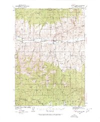 1940 Mount Vernon1959 Print · USGSMount Vernon and the John Day River valley are shown here just before mid-century, capturing a landscape of remote ranches and forest lookouts. Genealogists can locate family landmarks like Fletcher Ranch, Belshaw Sch, and the Cinnabar Mine.2 unique versions available
 - 1943 Map of Mount Vernon
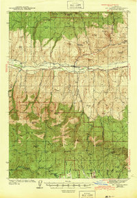 1943 Mount Vernon1943 Print · USGSMount Vernon and the surrounding Grant County highlands are seen here during the early 1940s as a hub for ranching and mercury mining. Genealogists and historians can locate early homesteads and community centers like the Belshaw Sch, Koehler Ranch, and the Cinnabar Mine.
End of results
Showing maps 1-2 of 2
Top cities near Mount Vernon
Frequently asked questions
- What are the different types of historical maps available for Mount Vernon?
- What is the oldest map of Mount Vernon?
- Where can I purchase historical maps of Mount Vernon for my home or office?
- Where can I download high-res historical maps of Mount Vernon?
- Are there historical topographic maps available for Mount Vernon?
- Is there historical aerial imagery available for Mount Vernon?
- Where are historical maps of Mount Vernon sourced from?