1990s Maps of Grants Pass, Oregon
Explore 2 historic maps of Grants Pass from the 1990s. These maps offer a rare glimpse into what life looked like during the 1990s — showing old roads, neighborhoods, homes, and landmarks that have changed or disappeared over time.
Whether you're researching your family's past, planning a metal detecting trip, or studying how Grants Pass's landscape evolved across the 1990s, these high-resolution maps are a powerful tool for exploring the history of this region.
- Focus on a specific era: All maps on this page are from the 1990s, giving you a focused view of this time period.
- See what’s changed: Compare century-old streets, trails, and buildings to today's modern landscape using overlays and satellite layers.
- Research with precision: Use these maps for genealogy, historical research, land use analysis, or educational projects.
- View, download, or print: Maps are fully viewable online in high resolution, and can be downloaded or printed for your own records.
Start exploring Grants Pass's history through authentic maps from the 1990s. This is your window into the past.
Grants Pass, OR maps
(2)- 1996 Map of Grants Pass, 1999 Print
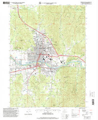 1996 Grants Pass1999 Print · USGSGrants Pass transitioned through the late twentieth century as a bustling river town surrounded by historic gold and quartz mines. Researchers can trace the development of the Rogue River corridor through landmarks like the Ida Mine, County Fairgrounds, and Croxton-Pioneer Memorial Park.
 - 1996 Map of Wilderville, 1999 Print
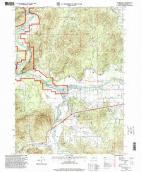 1996 Wilderville1999 Print · USGSThe Josephine County riverfront in the mid-nineties shows a landscape of established communities and active waterways. Researchers can locate the Wilderville settlement and Cemetery, or trace water features like the Main Canal and the Applegate River.
End of results
Showing maps 1-2 of 2
Top cities near Grants Pass
Top neighborhoods of Grants Pass
Frequently asked questions
- What are the different types of historical maps available for Grants Pass?
- What is the oldest map of Grants Pass?
- Where can I purchase historical maps of Grants Pass for my home or office?
- Where can I download high-res historical maps of Grants Pass?
- Are there historical topographic maps available for Grants Pass?
- Is there historical aerial imagery available for Grants Pass?
- Where are historical maps of Grants Pass sourced from?