1940s Maps of Alpha, Oregon
Explore 2 historic maps of Alpha from the 1940s. These maps offer a rare glimpse into what life looked like during the 1940s — showing old roads, neighborhoods, homes, and landmarks that have changed or disappeared over time.
Whether you're researching your family's past, planning a metal detecting trip, or studying how Alpha's landscape evolved across the 1940s, these high-resolution maps are a powerful tool for exploring the history of this region.
- Focus on a specific era: All maps on this page are from the 1940s, giving you a focused view of this time period.
- See what’s changed: Compare century-old streets, trails, and buildings to today's modern landscape using overlays and satellite layers.
- Research with precision: Use these maps for genealogy, historical research, land use analysis, or educational projects.
- View, download, or print: Maps are fully viewable online in high resolution, and can be downloaded or printed for your own records.
Start exploring Alpha's history through authentic maps from the 1940s. This is your window into the past.
Alpha, OR maps
(2)- 1941 Map of Blachly
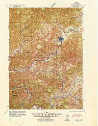 1941 Blachly1941 Print · USGSCoastal Oregon timber country comes into focus in the early 1940s, highlighting a landscape of remote sawmills and early forest management. Trace the legacy of the local lumber industry through the Logging Flume (Abandoned), the Triangle Lumber Co, and the Southern Pacific rail line.
 - 1942 Map of Blachly
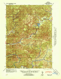 1942 Blachly1942 Print · USGSThe Oregon Coast Range in the early 1940s reveals a landscape of isolated ranches and timber camps connected by the Siuslaw River. Genealogists and historians can trace family properties like Haywire Ranch and Bessonette Ranch or locate the Triangle Lake CCC Camp and the Lyons Sch.
End of results
Showing maps 1-2 of 2
Frequently asked questions
- What are the different types of historical maps available for Alpha?
- What is the oldest map of Alpha?
- Where can I purchase historical maps of Alpha for my home or office?
- Where can I download high-res historical maps of Alpha?
- Are there historical topographic maps available for Alpha?
- Is there historical aerial imagery available for Alpha?
- Where are historical maps of Alpha sourced from?