1900s (20th Century) Maps of Westfir, Oregon
Explore 12 historic maps of Westfir from the 1900s (20th Century). These maps offer a rare glimpse into what life looked like during the 1900s — showing old roads, neighborhoods, homes, and landmarks that have changed or disappeared over time.
Whether you're researching your family's past, planning a metal detecting trip, or studying how Westfir's landscape evolved across the 1900s, these high-resolution maps are a powerful tool for exploring the history of this region.
- Focus on a specific era: All maps on this page are from the 1900s, giving you a focused view of this time period.
- See what’s changed: Compare century-old streets, trails, and buildings to today's modern landscape using overlays and satellite layers.
- Research with precision: Use these maps for genealogy, historical research, land use analysis, or educational projects.
- View, download, or print: Maps are fully viewable online in high resolution, and can be downloaded or printed for your own records.
Start exploring Westfir's history through authentic maps from the 1900s. This is your window into the past.
Westfir, OR maps
(12)- 1925 Map of Waldo Lake
 1925 Waldo Lake1925 Print · USGSThe High Cascades near the Lane and Klamath county line are shown here in the mid-1920s as a frontier of forestry and high-country ranching. Trace early landmarks like the State Fish Hatchery, the High Prairie School, and the remote Hills Ranch.4 unique versions available
 - 1935 Map of Lowell
 1935 Lowell1935 Print · USGSIn the mid-1930s, this region of the Willamette foothills was a busy landscape of timber and rail. Researchers can trace rural school districts like Unity Sch, small post offices at Fall Creek PO, and the path of the Southern Pacific railroad.
 - 1942 Map of Lowell
 1942 Lowell1942 Print · USGSThe Willamette River valley and the foothills of the Cascades are captured here before the construction of major dams and reservoirs. Genealogists can trace family locations at the Smithson Homestead, early schools like Unity Sch, and the remote Bohemia Post Office.3 unique versions available
 - 1955 Map of Hardesty Mtn, 1957 Print
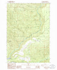
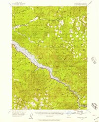 1955 Hardesty Mtn1957 Print · USGSThe Willamette National Forest in the mid-fifties reveals a landscape defined by the newly formed Lookout Point Reservoir and timber operations. Genealogists and historians can trace the rail-side life of Westfir, locate the Westfir HS, or find old forest sites like Black Canyon Camp.3 unique versions available
 - 1956 Map of Sardine Butte, 1958 Print
 1956 Sardine Butte1958 Print · USGSThe timber country of Lane County is captured here in the mid-1950s, centered on the confluence near Oakridge. Genealogists and local historians can trace family sites at Forestvale Cemetery or locate old forest outposts like Highland Cabin and Ironside Mine.2 unique versions available
 - 1958 Map of Roseburg, 1960 Print
 1958 Roseburg1960 Print · USGSThe timber valleys and high volcanic peaks of Southern Oregon are captured here in the late fifties. Researchers can trace the Southern Pacific rail line through historic settlements like Cottage Grove, Yoncalla, and Oakridge near the Cascade Range crest.4 unique versions available
 - 1959 Map of Roseburg
 1959 Roseburg1959 Print · USGSThe Umpqua and Willamette valleys meet the high Cascades in this late-fifties study of Southern Oregon's timber and rail corridors. Genealogists and researchers can trace the Southern Pacific RR through historic towns like Roseburg, Yoncalla, and Cottage Grove.
 - 1983 Map of Oakridge
 1983 Oakridge1983 Print · USGSThe Cascades of Lane County are shown in the early eighties, centered on the timber and rail corridors of the Willamette. Genealogists and historians can trace the Southern Pacific line through Oakridge or find old mining sites like Mayflower Mine.
 - 1986 Map of Westfir West
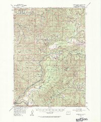
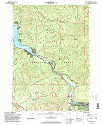
 1986 Westfir West1986 Print · USGSLane County in the mid-eighties shows a landscape of timber management and riverfront recreation along the Middle Fork Willamette River. Trace the Southern Pacific rail line past the Hampton boating site and backcountry locations like Lone Wolf Shelter.
 - 1986 Map of Westfir East
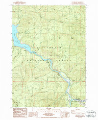
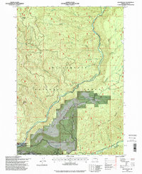
 1986 Westfir East1986 Print · USGSThe river confluence at Westfir and Oakridge is captured in the mid-1980s, showcasing the intersection of mountain timberlands and town life. Researchers can trace the era's forest infrastructure through the Flat Creek Work Center, Camp 6, and the High Prairie plateau.
 - 1997 Map of Westfir East, 1998 Print
 1997 Westfir East1998 Print · USGSThe convergence of the North and Middle Forks of the Willamette River defines this 1990s look at timber and transit hubs in the Cascades. Researchers can locate the Oakridge Airport, the Rigdon Work Center, and local landmarks like Buckhead Shelter and High Prairie.
 - 1997 Map of Westfir West, 1998 Print
 1997 Westfir West1998 Print · USGSThe Middle Fork Willamette River corridor in the late nineties shows a landscape defined by forestry and river-based industry. Genealogists and hikers can trace the growth of Westfir near the Northern tracks or locate remote spots like Shady Dell and Hampton.
End of results
Showing maps 1-12 of 12
Top cities near Westfir
Frequently asked questions
- What are the different types of historical maps available for Westfir?
- What is the oldest map of Westfir?
- Where can I purchase historical maps of Westfir for my home or office?
- Where can I download high-res historical maps of Westfir?
- Are there historical topographic maps available for Westfir?
- Is there historical aerial imagery available for Westfir?
- Where are historical maps of Westfir sourced from?