1940s Maps of Lincoln City, Oregon
Explore 7 historic maps of Lincoln City from the 1940s. These maps offer a rare glimpse into what life looked like during the 1940s — showing old roads, neighborhoods, homes, and landmarks that have changed or disappeared over time.
Whether you're researching your family's past, planning a metal detecting trip, or studying how Lincoln City's landscape evolved across the 1940s, these high-resolution maps are a powerful tool for exploring the history of this region.
- Focus on a specific era: All maps on this page are from the 1940s, giving you a focused view of this time period.
- See what’s changed: Compare century-old streets, trails, and buildings to today's modern landscape using overlays and satellite layers.
- Research with precision: Use these maps for genealogy, historical research, land use analysis, or educational projects.
- View, download, or print: Maps are fully viewable online in high resolution, and can be downloaded or printed for your own records.
Start exploring Lincoln City's history through authentic maps from the 1940s. This is your window into the past.
Lincoln City, OR maps
(7)- 1941 Map of Nestucca Bay
 1941 Nestucca Bay1941 Print · USGSThe Oregon coast at the start of the 1940s reveals a mix of timber industry and early seaside tourism. Trace the history of coastal work and recreation through labels like the Miles Lake CCC Camp, Hebo Alder Mill, and the many fire lookouts.
 - 1941 Map of Cape Foulweather
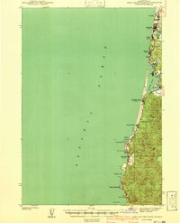 1941 Cape Foulweather1941 Print · USGSThe Oregon coast at the start of the 1940s reveals a chain of separate seaside villages along the Pacific. Genealogists and historians can trace early boundaries of Oceanlake, Delake, and Taft or locate the old ferry crossing at Kernville.
 - 1942 Map of Euchre Mtn
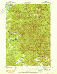 1942 Euchre Mtn1942 Print · USGSCoastal Lincoln County during the early 1940s reveals a landscape of isolated timber outposts and river-oriented landings. Researchers can trace historic river access at Melco Landing and Mowrey Landing or locate family landmarks like Horner Ranch and the Ojalla Bridge.
 - 1942 Map of Nestucca Bay
 1942 Nestucca Bay1942 Print · USGSCoastal Oregon is captured here during the early war years as timber and forest management shaped the local economy. Researchers can locate vanished infrastructure like the Hebohalder Mill and Powder House, or trace the development of Pacific City and Neskowin.
 - 1943 Map of Euchre Mtn
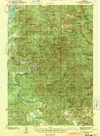 1943 Euchre Mtn1943 Print · USGSThe Oregon Coast Range at the start of the 1940s reveals a river-driven landscape shaped by the Siletz River and deep forest. Genealogists and historians can trace riverside settlements and river access points like Mack Landing, the Horner Ranch, and the Ojalla Bridge near The Maples.
 - 1944 Map of Cape Foulweather
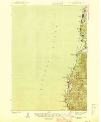 1944 Cape Foulweather1944 Print · USGSThe Oregon coastline north of Newport appears here in the late 1930s as a series of emerging seaside communities connected by the Coast Highway. Researchers can trace the early footprints of Depoe Bay and Taft, or locate landmarks like Devils Lake and Otter Rock.
 - 1948 Map of Vancouver, 1957 Print
 1948 Vancouver1957 Print · USGSPost-war growth transforms the river valleys of the Pacific Northwest as the timber and rail economy thrives. Trace family roots in Tillamook or Oregon City, and locate vanished landmarks like the spit at Bayocean or the Skamania Mine.
End of results
Showing maps 1-7 of 7
Top cities near Lincoln City
Top neighborhoods of Lincoln City
- Nelscott historical maps
- Roads End historical maps
- Wecoma Beach historical maps
- Cutler City historical maps
- Delake historical maps
- Oceanlake historical maps
See more
Frequently asked questions
- What are the different types of historical maps available for Lincoln City?
- What is the oldest map of Lincoln City?
- Where can I purchase historical maps of Lincoln City for my home or office?
- Where can I download high-res historical maps of Lincoln City?
- Are there historical topographic maps available for Lincoln City?
- Is there historical aerial imagery available for Lincoln City?
- Where are historical maps of Lincoln City sourced from?