1940s Maps of Salem, Oregon
Explore 5 historic maps of Salem from the 1940s. These maps offer a rare glimpse into what life looked like during the 1940s — showing old roads, neighborhoods, homes, and landmarks that have changed or disappeared over time.
Whether you're researching your family's past, planning a metal detecting trip, or studying how Salem's landscape evolved across the 1940s, these high-resolution maps are a powerful tool for exploring the history of this region.
- Focus on a specific era: All maps on this page are from the 1940s, giving you a focused view of this time period.
- See what’s changed: Compare century-old streets, trails, and buildings to today's modern landscape using overlays and satellite layers.
- Research with precision: Use these maps for genealogy, historical research, land use analysis, or educational projects.
- View, download, or print: Maps are fully viewable online in high resolution, and can be downloaded or printed for your own records.
Start exploring Salem's history through authentic maps from the 1940s. This is your window into the past.
Salem, OR maps
(5)- 1940 Map of McMinnville
 1940 McMinnville1940 Print · USGSWillamette Valley life centered on river and rail transit in the 1940s, from the streets of McMinnville to the fertile bottomlands. Local historians can trace early school sites like Grub College and river crossings such as the Wheatland Ferry.3 unique versions available
 - 1940 Map of Salem
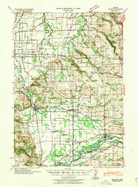
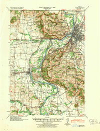 1940 Salem1940 Print · USGSThe Willamette Valley thrives in the early days of the war, as Salem expands around its rail hubs and state institutions. Researchers can trace the legacy of the Southern Pacific line and find vanished local landmarks like the Poor Farm School for the Deaf or Oak Grove Church.
 - 1940 Map of Mount Angel
 1940 Mount Angel1940 Print · USGSMarion County farming and institutional life are captured here just before the war, showing a valley crisscrossed by rail and river. Genealogists can locate family landmarks like St Benedict, the Pioneer Cemetery, and nearly twenty rural schoolhouses.
 - 1941 Map of Stayton
 1941 Stayton1941 Print · USGSMarion County agriculture and industry are in full swing just before the war as rail lines connect the Waldo Hills to the river. Trace the locations of dozens of vanished rural schoolhouses like Rocky Point School and rail stops at Durbin or Gesner.
 - 1948 Map of Vancouver, 1957 Print
 1948 Vancouver1957 Print · USGSPost-war growth transforms the river valleys of the Pacific Northwest as the timber and rail economy thrives. Trace family roots in Tillamook or Oregon City, and locate vanished landmarks like the spit at Bayocean or the Skamania Mine.
End of results
Showing maps 1-5 of 5
Top cities near Salem
- Keizer historical maps
- Woodburn historical maps
- Monmouth historical maps
- Independence historical maps
- Stayton historical maps
- Mount Angel historical maps
See more
Top neighborhoods of Salem
- Chemawa historical maps
- Liberty historical maps
- West Salem historical maps
- South Salem historical maps
- Grant historical maps
- Highland historical maps
See more
Frequently asked questions
- What are the different types of historical maps available for Salem?
- What is the oldest map of Salem?
- Where can I purchase historical maps of Salem for my home or office?
- Where can I download high-res historical maps of Salem?
- Are there historical topographic maps available for Salem?
- Is there historical aerial imagery available for Salem?
- Where are historical maps of Salem sourced from?