1950s Maps of Salem, Oregon
Explore 9 historic maps of Salem from the 1950s. These maps offer a rare glimpse into what life looked like during the 1950s — showing old roads, neighborhoods, homes, and landmarks that have changed or disappeared over time.
Whether you're researching your family's past, planning a metal detecting trip, or studying how Salem's landscape evolved across the 1950s, these high-resolution maps are a powerful tool for exploring the history of this region.
- Focus on a specific era: All maps on this page are from the 1950s, giving you a focused view of this time period.
- See what’s changed: Compare century-old streets, trails, and buildings to today's modern landscape using overlays and satellite layers.
- Research with precision: Use these maps for genealogy, historical research, land use analysis, or educational projects.
- View, download, or print: Maps are fully viewable online in high resolution, and can be downloaded or printed for your own records.
Start exploring Salem's history through authentic maps from the 1950s. This is your window into the past.
Salem, OR maps
(9)- 1950 Map of Vancouver
 1950 Vancouver1950 Print · USGSCoastal Oregon and the lower Columbia River valley are captured in detail just after the war. Researchers can trace historic rail routes like the Southern Pacific or locate early settlements such as Vernonia, Gaston, and the Grand Ronde Indian Reservation.
 - 1950 Map of Vancouver, 1951 Print
 1950 Vancouver1951 Print · USGSThe Pacific Northwest urban corridor meets the rugged coast in the years following the war, showing the expansion of Portland and Vancouver. Genealogists and historians can trace the reach of the Southern Pacific RR and locate coastal communities like Tillamook, Seaside, and Tolovana Park.
 - 1953 Map of Salem
 1953 Salem1953 Print · USGSMid-century Oregon comes to life through this detailed survey of the Willamette Valley and the adjacent Pacific coastline. Researchers can trace the rail lines of the Southern Pacific RR, visit rural hubs like Fairview School, or locate coastal landmarks like the Yaquina Head Lighthouse.
 - 1954 Map of Salem
 1954 Salem1954 Print · USGSMid-century Western Oregon is centered on the productive Willamette River valley as its cities and infrastructure expand toward the mountains. Genealogists and historians can trace the rail lines of the Southern Pacific RR and Oregon Electric Ry through towns like Dallas, Independence, and Brownsville.
 - 1957 Map of Gervais, 1958 Print
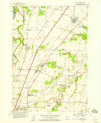 1957 Gervais1958 Print · USGSMid-century Marion County farming life centers on the rich soils of French Prairie and the transition of Lake Labish into agricultural land. Researchers can trace the layout of the U S Indian School Chemawa or locate family roots near St Louis and Labish Village.3 unique versions available
 - 1957 Map of Mission Bottom, 1958 Print
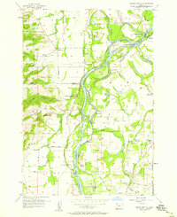 1957 Mission Bottom1958 Print · USGSThe Willamette Valley in the late fifties is captured here through its river landings and rich prairie lands. Genealogists can trace family landmarks like Claggett Cem or follow the path of the Wheatland Ferry and the Oregon Electric railroad.4 unique versions available
 - 1957 Map of Stayton, 1959 Print
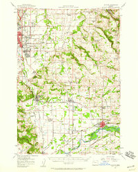 1957 Stayton1959 Print · USGSMarion County farming communities and the eastern fringes of the state capital are captured here during the late fifties. Genealogists can trace family names and rural landmarks across the Waldo Hills, including the John T Wisner Cemetery and numerous country schools like Rickey School.2 unique versions available
 - 1957 Map of Salem, 1959 Print
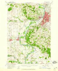 1957 Salem1959 Print · USGSThe Willamette Valley thrives during the mid-fifties as the state capital expands across the river into West Salem. Genealogists can trace family names and landmarks through Eola Cem, Pioneer Cemetery, and the riverside rail stops of the Oregon Electric line.2 unique versions available
 - 1958 Map of Vancouver, 1968 Print
 1958 Vancouver1968 Print · USGSThe Lower Columbia and Willamette valleys thrive in the late sixties as major rail and river hubs. Genealogists and historians can trace the development of Portland, identify the grounds of Camp Withycombe, and locate coastal landmarks from Tillamook Head to Garibaldi.3 unique versions available
End of results
Showing maps 1-9 of 9
Top cities near Salem
- Keizer historical maps
- Woodburn historical maps
- Monmouth historical maps
- Independence historical maps
- Stayton historical maps
- Mount Angel historical maps
See more
Top neighborhoods of Salem
- Chemawa historical maps
- Liberty historical maps
- West Salem historical maps
- South Salem historical maps
- Grant historical maps
- Highland historical maps
See more
Frequently asked questions
- What are the different types of historical maps available for Salem?
- What is the oldest map of Salem?
- Where can I purchase historical maps of Salem for my home or office?
- Where can I download high-res historical maps of Salem?
- Are there historical topographic maps available for Salem?
- Is there historical aerial imagery available for Salem?
- Where are historical maps of Salem sourced from?