1940s Maps of Portland, Oregon
Explore 8 historic maps of Portland from the 1940s. These maps offer a rare glimpse into what life looked like during the 1940s — showing old roads, neighborhoods, homes, and landmarks that have changed or disappeared over time.
Whether you're researching your family's past, planning a metal detecting trip, or studying how Portland's landscape evolved across the 1940s, these high-resolution maps are a powerful tool for exploring the history of this region.
- Focus on a specific era: All maps on this page are from the 1940s, giving you a focused view of this time period.
- See what’s changed: Compare century-old streets, trails, and buildings to today's modern landscape using overlays and satellite layers.
- Research with precision: Use these maps for genealogy, historical research, land use analysis, or educational projects.
- View, download, or print: Maps are fully viewable online in high resolution, and can be downloaded or printed for your own records.
Start exploring Portland's history through authentic maps from the 1940s. This is your window into the past.
Portland, OR maps
(8)- 1940 Map of Tualatin
 1940 Tualatin1940 Print · USGSThe Tualatin Valley comes into sharp focus during the late 1930s, showing the early footprints of Beaverton and Tigard amid a vast network of rail lines. Researchers can trace historic family schoolhouses like Witch Hazel School and locate the original path of Boones Ferry Road near Wilsonville.
 - 1940 Map of Hillsboro
 1940 Hillsboro1940 Print · USGSThe Tualatin Valley and the Columbia River confluence meet in this 1940 survey of the Hillsboro and North Portland region. Researchers can trace early twentieth-century rail lines like the Oregon Electric or locate historic rural landmarks such as Mountain View Cemetery and the Mason Hill School.
 - 1940 Map of Boring
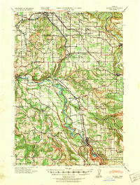 1940 Boring1940 Print · USGSClackamas and Multnomah Counties are captured in the late thirties, documenting a landscape shaped by the Clackamas River and electric rail lines. Trace the route of the Cazadero Line or locate family roots at Mt Zion Cem and Lusted School.
 - 1940 Map of Portland
 1940 Portland1940 Print · USGSThe Portland and Vancouver riverfronts are captured here just before the massive industrial shifts of the mid-century. Genealogists and historians can locate early landmarks like Vancouver Barracks, the University of Portland, and Mundays Ferry.4 unique versions available
 - 1941 Map of Oregon City
 1941 Oregon City1941 Print · USGSThe Lower Willamette Valley thrived on a mix of river power and rail transit in the early 1940s. Genealogists can trace family footprints across dozens of local school districts, from Petes Mountain School to Harmony School, and locate landmarks like Willamette Falls and the Ten O'clock Church.
 - 1941 Map of Camas
 1941 Camas1941 Print · USGSThe Columbia River corridor is captured here just before the mid-century, showing the bustling industrial towns of Camas and Washougal alongside a rural network of country schools. Genealogists and historians can trace family roots through landmarks like the Silver Star Mine, Cemetery Hill, and dozens of local schoolhouses such as Harmony Sch.
 - 1942 Map of Camas
 1942 Camas1942 Print · USGSThe Columbia River corridor is captured here in the early 1940s, showing the industrial heart of Camas and the rural outskirts of Gresham. Genealogists and historians can trace early schools like Twelvemile Corner Sch and the location of the Silver Star Mine.2 unique versions available
 - 1948 Map of Vancouver, 1957 Print
 1948 Vancouver1957 Print · USGSPost-war growth transforms the river valleys of the Pacific Northwest as the timber and rail economy thrives. Trace family roots in Tillamook or Oregon City, and locate vanished landmarks like the spit at Bayocean or the Skamania Mine.
End of results
Showing maps 1-8 of 8
Top cities near Portland
- Vancouver historical maps
- Gresham historical maps
- Hillsboro historical maps
- Beaverton historical maps
- Tigard historical maps
- Lake Oswego historical maps
See more
Top neighborhoods of Portland
- Harborton historical maps
- Healy Heights historical maps
- East Columbia historical maps
- Marshall Park historical maps
- Far Southwest historical maps
- Argay Terrace historical maps
See more
Frequently asked questions
- What are the different types of historical maps available for Portland?
- What is the oldest map of Portland?
- Where can I purchase historical maps of Portland for my home or office?
- Where can I download high-res historical maps of Portland?
- Are there historical topographic maps available for Portland?
- Is there historical aerial imagery available for Portland?
- Where are historical maps of Portland sourced from?