1940 Map of Tualatin
USGS Topo · Published 1940About this map
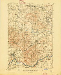
Beaverton and Tigard appear as emerging hubs in this tactical survey, which details a landscape transitioning from rural farmstead blocks into early suburban grid patterns. The Tualatin River snakes through the center of the sheet, connecting a network of smaller communities like Scholls, Farmington, and Kinton. Transportation is a primary focus, illustrating the heavy reliance on the Southern Pacific and Oregon Electric railroads, alongside notable thoroughfares like Boones Ferry Road.
Find a feature on this map
108 named features on this map. Tap any name to fly to it.
Don’t see what you’re looking for? This feature index may not catch every label — zoom into the map to look around manually.
Map Details
Editions of this 1940 Tualatin Map
This is the sole edition of this map. No revisions or reprints were ever made.
Historical Maps of Portland Through Time
3 maps found