1900s (20th Century) Maps of Rufus, Oregon
Explore 9 historic maps of Rufus from the 1900s (20th Century). These maps offer a rare glimpse into what life looked like during the 1900s — showing old roads, neighborhoods, homes, and landmarks that have changed or disappeared over time.
Whether you're researching your family's past, planning a metal detecting trip, or studying how Rufus's landscape evolved across the 1900s, these high-resolution maps are a powerful tool for exploring the history of this region.
- Focus on a specific era: All maps on this page are from the 1900s, giving you a focused view of this time period.
- See what’s changed: Compare century-old streets, trails, and buildings to today's modern landscape using overlays and satellite layers.
- Research with precision: Use these maps for genealogy, historical research, land use analysis, or educational projects.
- View, download, or print: Maps are fully viewable online in high resolution, and can be downloaded or printed for your own records.
Start exploring Rufus's history through authentic maps from the 1900s. This is your window into the past.
Rufus, OR maps
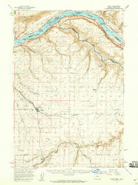
(9)- 1953 Map of The Dalles, 1965 Print
 1953 The Dalles1965 Print · USGSThe Columbia River Gorge at mid-century shows a region being transformed by massive hydroelectric dams and a growing highway network. Researchers can trace the development of The Dalles Dam, locate the Maryhill Museum, and find old rail stops in Rufus, Wishram, and Arlington.3 unique versions available
 - 1956 Map of The Dalles
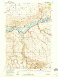
 1956 The Dalles1956 Print · USGSThe Columbia River Gorge and the high Cascades are captured in the mid-1950s, showing a vital corridor of rail and road. Researchers can trace the original path of The Old Oregon Trail or locate historical landmarks like the Maryhill Museum and Mount Hood.
 - 1957 Map of The Dalles
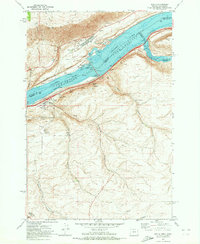
 1957 The Dalles1957 Print · USGSThe Columbia River Gorge and the high plateaus of the mid-1950s come alive on this detailed survey of northern Oregon and southern Washington. Researchers can trace the path of the Oregon Trail and The Old Barlow Road alongside river towns like The Dalles and Wishram.
 - 1957 Map of Wasco, 1959 Print
 1957 Wasco1959 Print · USGSSherman County and the Columbia River frontier are captured in the late fifties, showing the vital rail and water routes of the Inland Empire. Researchers can trace historic settlements from Wasco to Klondike and locate family landmarks like Sunrise Cemetery.2 unique versions available
 - 1957 Map of Wishram, 1959 Print
 1957 Wishram1959 Print · USGSThe Columbia Gorge in the late fifties was a powerhouse of rail transport and river management. Trace the junction of the S P & S and Union Pacific railroads near Wishram, and find rural landmarks like the Stonehenge Memorial and Douglas Hollow School.2 unique versions available
 - 1971 Map of Rufus, 1973 Print
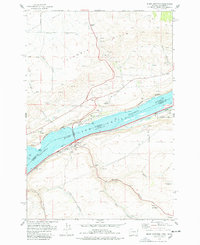
 1971 Rufus1973 Print · USGSThe Columbia River corridor is captured here in the early seventies, just as the John Day Dam transformed the region's geography. Trace the industrial landscape from Rufus to Cliffs, along with rail lines like the Union Pacific and deep canyons like China Hollow.
 - 1977 Map of Biggs Junction, 1978 Print
 1977 Biggs Junction1978 Print · USGSThe Columbia River gorge in the late 1970s reveals a landscape shaped by rail, water, and unique monuments. Researchers can trace the legacy of the Maryhill area through the Stonehenge Memorial, the tracks of the Union Pacific, and the small settlement at Thornberry.
 - 1980 Map of Goldendale, 1981 Print
 1980 Goldendale1981 Print · USGSThe Columbia River corridor in the 1980s was a critical junction of rail, water, and highway commerce between Washington and Oregon. Genealogists and historians can trace riverside settlements like Wishram, high-country towns like Bickleton, and the grounds of the Maryhill Museum.
 - 1994 Map of Biggs Junction, 1995 Print
 1994 Biggs Junction1995 Print · USGSThe Columbia River corridor is captured here in the mid-nineties, showing the vital connection between Maryhill, Washington and Biggs Junction, Oregon. Trace the cultural and transit history of the gorge through landmarks like the Stonehenge Memorial, the Maryhill Museum, and the rail-and-road hub at Rufus.
End of results
Showing maps 1-9 of 9
Top cities near Rufus
Frequently asked questions
- What are the different types of historical maps available for Rufus?
- What is the oldest map of Rufus?
- Where can I purchase historical maps of Rufus for my home or office?
- Where can I download high-res historical maps of Rufus?
- Are there historical topographic maps available for Rufus?
- Is there historical aerial imagery available for Rufus?
- Where are historical maps of Rufus sourced from?