1900s (20th Century) Maps of Pendleton, Oregon
Explore 7 historic maps of Pendleton from the 1900s (20th Century). These maps offer a rare glimpse into what life looked like during the 1900s — showing old roads, neighborhoods, homes, and landmarks that have changed or disappeared over time.
Whether you're researching your family's past, planning a metal detecting trip, or studying how Pendleton's landscape evolved across the 1900s, these high-resolution maps are a powerful tool for exploring the history of this region.
- Focus on a specific era: All maps on this page are from the 1900s, giving you a focused view of this time period.
- See what’s changed: Compare century-old streets, trails, and buildings to today's modern landscape using overlays and satellite layers.
- Research with precision: Use these maps for genealogy, historical research, land use analysis, or educational projects.
- View, download, or print: Maps are fully viewable online in high resolution, and can be downloaded or printed for your own records.
Start exploring Pendleton's history through authentic maps from the 1900s. This is your window into the past.
Pendleton, OR maps
(7)- 1935 Map of Pendleton
 1935 Pendleton1935 Print · USGSPendleton and the surrounding Umatilla River valley are captured in the mid-1930s as the region solidified its role as a transportation and agricultural hub. Genealogists can locate numerous named rural schoolhouses such as Campbell Sch and North Yoakum Sch, or trace family sites near the Umatilla Indian Reservation and Cabbage Hill.3 unique versions available
 - 1953 Map of Pendleton, 1957 Print
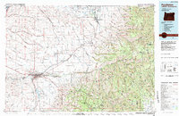
 1953 Pendleton1957 Print · USGSNortheastern Oregon and the Columbia River frontier are captured here in the early fifties, a time of massive federal infrastructure projects. Researchers can trace the historic route of The Old Oregon Trail as it passes near the Umatilla Ordnance Depot and the new McNary Dam.4 unique versions available
 - 1956 Map of Pendleton
 1956 Pendleton1956 Print · USGSNortheastern Oregon’s high plateau and timbered peaks appear here in the mid-fifties, during a time of major military and hydroelectric development. Trace the path of The Old Oregon Trail alongside modern landmarks like McNary Dam and the Umatilla Ordnance Depot.
 - 1966 Map of Pendleton, 1967 Print
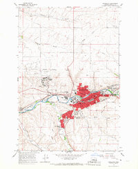 1966 Pendleton1967 Print · USGSPendleton at the height of its mid-century growth remains tied to its rail-and-river roots along the Umatilla River. Genealogists and local historians can trace the Old Indian Treaty Bdy, locate graves at Olney Cemetery, or find the historic Roundup Grounds.3 unique versions available
 - 1966 Map of Mission, 1967 Print
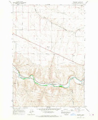
 1966 Mission1967 Print · USGSUmatilla County in the mid-sixties reveals a landscape of high-desert agriculture and tribal administration centered on Mission. Genealogists and historians can trace the Old Agency Cem, the Tutuhilla Mission, and the Rodeo Grounds.2 unique versions available
 - 1966 Map of Barnhart, 1967 Print
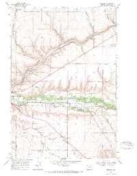
 1966 Barnhart1967 Print · USGSUmatilla County in the mid-sixties shows a bustling transport corridor where the Umatilla River and Union Pacific rail lines meet. Genealogists and local historians can trace the developments at Barnhart, the residential layout of Rieth, and rural landmarks like the quarry and Stage Gulch.2 unique versions available
 - 1983 Map of Pendleton, 1984 Print
 1983 Pendleton1984 Print · USGSPendleton and the Blue Mountain foothills are captured here in the early eighties as a hub of rail, ranching, and forest management. Genealogists and historians can trace local landmarks like Indian Agency Hdqrs, Bingham Springs, and the Union Pacific line.
End of results
Showing maps 1-7 of 7
Top cities near Pendleton
Top neighborhoods of Pendleton
Frequently asked questions
- What are the different types of historical maps available for Pendleton?
- What is the oldest map of Pendleton?
- Where can I purchase historical maps of Pendleton for my home or office?
- Where can I download high-res historical maps of Pendleton?
- Are there historical topographic maps available for Pendleton?
- Is there historical aerial imagery available for Pendleton?
- Where are historical maps of Pendleton sourced from?